
Vadsø
| coat of arms | map | ||
|---|---|---|---|

|
|
||
| Basic data | |||
| Commune number : | 5405 | ||
| Province (county) : | Troms and Finnmark | ||
| Administrative headquarters: | Vadsø | ||
| Coordinates : | 70 ° 0 ′ N , 29 ° 0 ′ E | ||
| Surface: | 1,257.85 km² | ||
| Residents: | 5,788 (Feb 27, 2020) | ||
| Population density : | 5 inhabitants per km² | ||
| Language form : | Bokmål | ||
| Website: | |||
| politics | |||
| Mayor : | Wenche Pedersen ( Ap ) (2019) | ||
| Located in the province of Troms and Finnmark | |||

|
|||

(Sami Čáhcesuolu,Kven:Vesisaari,Вадсё) is a city and amunicipalityinnorthern Norway. The city is the seat of theFylkesmann(governor) of the province ofTroms og Finnmark.
Situation and facts
The city is located in the northeastern part of Norway near Kirkenes on the Varangerfjord . The geographical location is 29 ° 46'8 "E, 70 ° 4'16" N. Vadsø has 5788 inhabitants (as of February 27, 2020).
In April 2006, Vadsø hosted the Snowkite World Championships.
coat of arms
Description : A silver reindeer head in red with antlers of the same color .
history
Vadsø was first settled by fishermen on the island in the 15th century and on the mainland from the 17th century. The witch trials carried out in Finnmark in the first half of the 17th century also resulted in the deaths of many women in Vadsø. The place developed into a trading and administrative center and received city rights in 1833.
In the 19th century there was a great wave of immigration from Finland . In 1875 2/3 of the population were Finnish-speaking. This is why Finnish is still taught in schools today.
The airships Norge ( Amundsen , Ellsworth , Nobile 1926) and Italia (Nobile 1928) each made a stopover in Vadsø before setting off from Ny-Ålesund for the North Pole . The anchor mast has been preserved to this day.
During the Second World War , Vadsø was converted into a fortress by the German occupiers. This was a main base for the 'North Varanger Subsection'. Gun emplacements and bunkers were built on the island of Store Vadsøya , just outside the town, and these are still in ruins today. The island was first connected to the mainland by a wooden bridge at this time. During fighting with the Allies , Vadsø was almost completely destroyed. Only a few houses remained. One of them now houses the museum.
In 1977 the immigration memorial was inaugurated by President Urho Kekkonen ( Finland ), King Olav V ( Norway ) and King Carl Gustav ( Sweden ).
Vadsø was the former capital until the province of Finnmark was dissolved in Troms og Finnmark in early 2020.
economy
The main branches of business are fishing, administration, construction and the service industry.
traffic
Vadsø is the penultimate landing stage for the Hurtigruten to the north. This is located on the offshore island Vadsøya .
From Vadsø Airport, located 3.7 km to the east , there are regular flights to Alta , Berlevåg , Båtsfjord , Hammerfest , Hasvik , Honningsvåg , Kirkenes , Mehamn , Sørkjosen , Tromsø and Vardø .
From Oslo you can reach Vadsø via European route 6 to Varangerbotn , or via Finland via European route 75 , which runs through Vadsø.
Vadsø can be reached via several bus routes operated by Veolia Transport :
- Route 505: Vestertana - Tana bru - Vadsø
- Route 506: Langnes - Tana bru - Vadsø
- Route 511: Båtsfjord - Tana bru (- Vadsø)
- Route 512: Berlevåg - Tana bru (- Vadsø)
- Route 515: Tana bru - Vadsø
- Route 520b: Kirkenes - Varangerbotn - Vadsø
- Route 525: Vardø - Vadsø
- Route 575: Rovagiedde - Tana bru - Vadsø
Naming
The Norse name was Vatnsøy , the first part is the genitive of vatn (water) and the second part comes from øy (island). The name means 'island with drinking water'.
Attractions

- Vadsø Museum (mainly shows the history of Finnish immigration)
- Immigration monument
- Vadsø Church (built 1958 )
- Airship - anchor mast of the polar expeditions by Roald Amundsen and Umberto Nobile (still standing today, see picture)
Twin cities
sons and daughters of the town
- Oddny Aleksandersen (* 1942), politician
- Lars Bohinen (* 1969), football player
- Stig Henrik Hoff (born 1965), actor
- Kåre Espolin Johnsen (1907–1994) artist (lived in Vadsø between 1909 and 1919)
- Erling Norvik (1928–1998), politician and journalist
- Steffen Nystrøm (* 1984), football player
- Morten Gamst Pedersen (* 1981), football player
- Sigurd Rushfeldt (* 1972), football player
- Gunnar Stålseth Bishop
- Karl Trasti (1917–1976), politician
photos
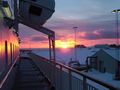
Vadsø one morning in February 2004
The church in Vadsø

The anchor mast of the airship by Roald Amundsen and Umberto Nobile

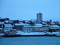
Aerial view of Vadsø

Vadsø harbor


Web links
- Vadsø Museum ( Memento from June 5, 2008 in the Internet Archive )
- Official website of Vadsø Municipality (Norwegian)
- Official website of the annual Varanger Music Festival in Vadsø (Norwegian)
- Pages of the Statistics Office of Norway ( Memento of July 9, 2011 in the Internet Archive ) (English)