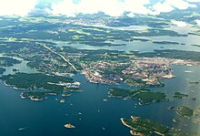
Oxelösund
| Oxelösund | ||||
|
||||
| State : | Sweden | |||
| Province (län): | Södermanland County | |||
| Historical Province (landskap): | Södermanland | |||
| Municipality : | Oxelösund | |||
| Coordinates : | 58 ° 40 ′ N , 17 ° 7 ′ E | |||
| SCB code : | 0820 | |||
| Status: | Crime scene | |||
| Residents : | 11,157 (December 31, 2015) | |||
| Area : | 11.6 km² | |||
| Population density : | 962 inhabitants / km² | |||
| List of perpetrators in Södermanland County | ||||
Oxelösund is a locality ( Tatort ) in the Swedish province of Södermanland County and the capital of the municipality of the same name . It is located 10 km southeast of Nyköping and is connected to it by riksväg 53 , built in 1965 . Both Nyköping and Oxelösund have ports on the Baltic Sea .
history
Beginnings
Oxelösund is a relatively young community. The natural harbor located here has been used for around 500 years. In the course of planning a railway line from the mining region of Grängesberg in Bergslagen directly to the Baltic Sea , the choice fell on the small settlement of Oxelösund. An earlier plan for a railway from Bergslagen to Lake Vänern only existed on paper.
In 1873 the Oxelösund – Flen – Västmanlands Järnvägsaktiebolag was founded, which bought up almost the entire peninsula near Oxelösund. With the new port and the ironworks built in 1913, the place grew rapidly.
20th century
At the beginning of the 1950s, Oxelösund was a typical Swedish small town with wooden houses and adjoining gardens. As one of the last places before the administrative redesign, Oxelösund received city rights in 1950 . The population was 5200 people. The economy was heavily influenced by industrial plants, with the ironworks being the largest employer with 700 employees.
In 1955, the Gränges Group , which already managed the port and the railway line and also owned several mines in Bergslagen, took over the majority of the shares in the ironworks. Most of the place was demolished to make way for a new ironworks. Today only a few villas in the village remind of the time around 1920. The ironworks created a completely new city center in the style of the 1950s and a motorway slip road to Nyköping .
In 1962, military installations were built on the offshore Femöre peninsula to defend the important port.
present
For many years there were various ferry connections from Oxelösund to Gotland and abroad. However, most of these connections have been discontinued. There are discussions about running the main ferry traffic between Gotland and mainland Sweden via Oxelösund as the current port in Nynäshamn does not have such a strategic location.
The community is a social democratic stronghold. The party received over 60 percent of the vote in many local elections.
Twin cities
Oxelösund has been a member of the Douzelage city association since 1998 .
sons and daughters of the town
- Nils-Olof Franzén (1916-1997), author
- Ralf Åkesson (* 1961), chess grandmaster
- Fredrik Gunnarsson (born 1965), actor
- Anders Thorén (* 1970), squash player
- Karolina Arewång-Højsgaard (* 1971), orienteer
Web links
Footnotes
- ↑ a b Statistiska centralbyrån : Land area per Tatort, folkmängd and invånare per square kilometer. Vart femte år 1960 - 2015 (database query)


