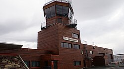
Båtsfjord Airport
| Båtsfjord lufthavn | |
|---|---|

|
|
| Characteristics | |
| ICAO code | ENBS |
| IATA code | BJF |
| Coordinates | |
| Height above MSL | 149 m (489 ft ) |
| Transport links | |
| Distance from the city center | around 7 km south of Båtsfjord |
| Street | Road 891 north to Båtsfjord; Roads 891 and 890 in a south-westerly direction to the 103 km distant |
| train | No rail connection |
| Local transport | Rental car and taxi |
| Basic data | |
| opening | 1999 |
| operator | Avinor |
| Passengers | 28,474 (2017) |
| Air freight | 4 t (2014) |
| Flight movements |
2,285 (2017) |
| Start-and runway | |
| 03/21 | 1000 m × 30 m asphalt |
The båtsfjord airport ( Norwegian : Båtsfjord lufthavn) is a North Norwegian airport in the province of Troms og Finnmark . It is located around two kilometers south of the Barents Sea coast and around seven kilometers south of the village of Båtsfjord in the municipality of the same name. The airport is operated by the Norwegian state - owned company Avinor .
The airport is currently only served by the Norwegian regional airline Widerøe (as of September 2013). There are direct scheduled flight connections to Berlevåg , Hammerfest , Honningsvåg , Kirkenes , Mehamn , Tromsø , Vadsø and Vardø . The direct connections to Alta , Hasvik and Sørkjosen no longer exist.
Web links
- Airport website (English / Norwegian)
Individual evidence
- ↑ Passengers 2017. (Excel (xlsx); 28 KB) In: avinor.no. Avinor , accessed September 14, 2018 (Norwegian / English).
- ↑ Frakt og Post 2014. (Excel (xlsx); 22 KB) In: avinor.no. Avinor , accessed September 14, 2018 (Norwegian / English).
- ↑ Flight movements 2017. (Excel (xlsx); 66 KB) In: avinor.no. Avinor , accessed September 14, 2018 (Norwegian / English).
- ↑ AIP ENBS - BÅTSFJORD. AIP , Norwegian, English. Avinor IPPC, accessed April 6, 2017 .
- ↑ a b He flyet i rod? Båtsfjord Airport ( Avinor ), accessed April 6, 2017 (Norwegian).