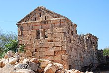
Jerada (Syria)
Jerada , Arabic جاراده, also Gerada, Jerade, Djerade; was a settlement in the early Byzantine period in the area of the Dead Cities in northwest Syria . The partly very well-preserved remains of ancient buildings lie at the lower edge and between the houses of a modern village.
location
Jerada is located in the Idlib governorate in the Jebel Zawiye area, the southern part of the northern Syrian limestone massif. In late antiquity the place belonged to the Apamene district, named after Apameia , the administrative capital at the time at the southern end of the mountainous region.
From the expressway that leads north from Maarat an-Numan towards Aleppo , after seven kilometers a side road branches off to the west in the village of Babila and after three kilometers you reach Jerada at the beginning of a flat hill. In the same karst and almost treeless landscape, which only allows grain to be grown on a few areas that have been cleared of stones, there are other ruins from the early Byzantine period. The directly neighboring places are Ruweiha , two kilometers northwest a little higher on a hill, and Dana (south) , about two kilometers southwest.
History and cityscape
The origins of the place go back to the 4th century AD, the peak of economic development was in the 5th and 6th centuries. Jerada was gradually abandoned in the following centuries and probably not repopulated until the beginning of the 20th century. From ancient times, a square tower, several residences and a church have been preserved in the center of the former settlement, about 300 meters east below the modern village center. Further ruins of stately buildings lie in the middle of and above the agricultural village, which consists of a grocery store and a dozen small homesteads with gardens in which figs, olives, apples and pomegranates thrive.
The five-story tower, made of rough limestone blocks in irregular layers, is adorned in the upper quarter by a cornice constructed from brackets inserted into the wall , on which flat stone slabs lie. The stone beams protruding from below on one side of the wall formed an outside toilet. Another tower has been preserved in the northern refade . There were numerous towers inside or outside of settlements, possibly serving as defense towers or as monastic retreats.
The large two-storey residential buildings ("villas") had porticoes on one long side , which were supported on both levels by columns as a sign of prosperity, the capitals of which show variants of the Ionic or Corinthian style. The windows are seldom bordered by ornamental bands, the external decoration of the walls is limited to a wide cornice with a hollow that forms the eaves and divides the gable. The masonry belt arches of the ground floor ceilings and passages are often still preserved. Most of the buildings had a courtyard surrounded by a high wall.
Probably the only church building is a three-aisled columned basilica from the 5th century. Its floor plan was first published by Howard Crosby Butler after his first American expedition in 1899/1900. He described a single-storey narthex that was located on the western gable side and was probably built at the same time as the nave in the direction of escape to the adjacent tower. In 1943 and 1970, the church was partially uncovered by Georges Tchalenko and examined in more detail.
The basilica had seven bays in the nave and a semicircular apse to the east, which was surrounded laterally by side rooms. The adjoining rooms had no connection to the apse, they took over, which was very rare, the round wall of the apse as a closure to the inside instead of the usually built-in straight partition. The windowless east wall just closed on the outside. There were two doors on the south long side, one on the north side and one in the middle of the west wall to the narthex, the entrance of which was formed by an architrave over two columns. In front of the north facade was a churchyard, which was bordered by large, well-preserved residences. The high arcade walls of the church have collapsed, part of the north and east walls have been preserved up to the eaves. There was the two-story Martyrion (reliquary chamber). Five of the twelve capitals have been preserved, one in the Ionic style, the rest in the Tuscan style.
literature
- Frank Rainer Scheck, Johannes Odenthal: Syria. High cultures between the Mediterranean and the Arabian desert . (DuMont art travel guide) 8th edition DuMont, Cologne 1998, p. 313 f, ISBN 3-7701-1337-3
- Edgar Baccache: Églises de village de la Syrie du Nord. Documents photographiques des archives de'l Institut Francais d'Archeologie due Proche-Orient . Paul Geuthner, Paris 1980, Vol. 2, pp. 125–129 (black and white photographs)
Individual evidence
- ^ Howard Crosby Butler: Early Churches in Syria. Fourth to Seventh Centuries. Princeton University Press, Princeton 1929, p. 102
- ^ Hermann Wolfgang Beyer: The Syrian church building. Studies of late antique art history. Walter de Gruyter, Berlin 1925, p. 66
- ↑ Christine Strube : Building decoration in the northern Syrian limestone massif. Vol. I. Forms of capitals, doors and cornices in the churches of the 4th and 5th centuries AD. Philipp von Zabern, Mainz 2002, pp. 152–154
Coordinates: 35 ° 43 ′ 26 " N , 36 ° 42 ′ 52" E

