Jerez de García Salinas
| Jerez de García Salinas | ||
|---|---|---|
|
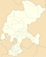
Coordinates: 22 ° 39 ′ N , 102 ° 59 ′ W Jerez de García Salinas on the map of Zacatecas
|
||
| Basic data | ||
| Country | Mexico | |
| State | Zacatecas | |
| Municipio | Jerez | |
| City foundation | 1569 | |
| Residents | 43,064 (2010) | |
| City insignia | ||
| Detailed data | ||
| surface | 18.0 km 2 | |
| Population density | 2,392 inhabitants / km 2 | |
| height | 2000 m | |
| Post Code | 99300 | |
| Website | ||
| Jerez - Santuario de Nuestra Señora de la Soledad | ||
| Jerez - Iglesia de la Inmaculada Concepción | ||
Jerez de García Salinas is a city with around 50,000 inhabitants and the capital of a municipality (municipio) with around 70,000 inhabitants in the center of the Mexican state of Zacatecas . The city is the administrative seat of the Municipio Jerez . Because of its historic city center, it is one of the Pueblos Mágicos .
location
Jerez de García Salinas is located in the central highlands of Mexico at an altitude of almost 2000 m . Mexico City is approx. 655 km (driving distance) in a southeast direction; Zacatecas , the state capital, is approximately 53 km to the northeast. The climate is temperate; Rain (approx. 455 mm / year) falls almost exclusively in the summer half-year.
Population development
| year | 2000 | 2005 | 2010 |
| Residents | 37,558 | 38,624 | 43,064 |
The slight but steady increase in population in the last few decades is mainly due to the continuing immigration of families from the surrounding villages. Only a small part of the community's mostly Indian-born residents speak the regional Nahuatl dialect; Colloquial language is mostly Spanish.
Population and economy
Corn, beans, vegetables, agaves and opuntia are grown in the fields in the area; There are many small craft workshops and shops in the city, and smaller industrial companies have also set up shop in the outskirts.
history
In pre- Hispanic times the area was inhabited by the Chichimecs and their subgroups such as the Zacatecs ; However, these did not leave any stone buildings. Around 1530, the region was explored and conquered by Cristóbal de Oñate , a conquistador from the Basque province of Álava . The city was founded in 1569; a small chapel, a square and a town hall ( casa consistorial ) were built. The present city layout with its right-angled streets was not built until the following centuries.
Attractions
- The most important religious building in the city is the baroque Santuario de Nuestra Señora de la Soledad with its double tower facade . While the basement floors of the bell towers are as usual without decoration, the two bell floors have a significantly richer design. The middle part of the facade, which is also articulated differently in terms of color, shows twisted columns in the style of Churriguerism .
- The single-tower parish church (Iglesia de la Inmaculada Concepción) , on the other hand, is much more simply designed, but shows a similar facade design in the middle part with twisted columns and a blown gable .
- The Edificio de la Torre, opposite the Santuario , with its two-storey outer walls in neo-Gothic style, was built as a school building at the end of the 19th century on the background of a donation of money and land from Don Pantaleón de la Torre . Today there is a cultural institution (casa de cultura) with a municipal library.
- The Portal de las Palomas , a representative building from the 19th century, is located at Plaza Tacuba .
- The Inguanzo portal , lined with a wide portico and a former trading house built at the end of the 19th century, also deserves attention.
- The same applies to the Teatro José María Hinojosa .
- The cemetery (Panteón de Dolores) , which was laid out outside the city in 1809, contains a large number of intricately designed grave monuments from the 19th and early 20th centuries.
Web links
- Jerez, sights - photo and information (Spanish)
- Jerez, Panteón de Dolores - Photo and information (Spanish)


