Jergeni Hill
| Jergeni Hill | |
|---|---|
|
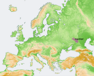
Location of the Jergeni hills |
|
| Highest peak | Gora Shared ( 222 m ) |
| location | Kalmykia , Rostov Oblast , Volgograd Oblast ( Russia ) |
| Coordinates | 46 ° 19 ′ N , 44 ° 16 ′ E |
The Jergenihügel (or Jergenihöhe ) are one to 222 m high around 330 km long ridge in the eastern part of Russia .
The hill landscape of the Jergeni hills extends in the southern part of the Eastern European Plain . It is located in Kalmykia as well as in the Oblasts of Volgograd and Rostov and is located west of the lower reaches of the Volga between the city of Volgograd in the north and the Manytn lowlands in the south. While the ridge merges into the hilly Eastern European Plain in the north and west , it gradually descends in the east and south-east into the flat Caspian Depression . Its highest point is the 222 m high Gora Schared.
The mountainous landscape of the Jergeni Hills is characterized by hilly areas in which various flowing waters have dug themselves. One of them is the Sal , which rises as a tributary of the Don in the Jergeni Hills . As an artificially created waterway, the Volga-Don Canal , which was built at the junction of the Jergeni hills to the north adjoining Volga plate , connects the rivers in an east-west direction , as indicated by its name.
Elista , located in the south of the Jergeni hills , is the largest city in the sparsely populated ridge.
Web links
- Article Jergenihügel in the Great Soviet Encyclopedia (BSE) , 3rd edition 1969–1978 (Russian)

