Sal (Don)
|
Sal Сал |
||
|
|
||
| Data | ||
| Water code | RU : 05010500112107000014981 | |
| location | Kalmykia , Rostov Oblast ( Russia ) | |
| River system | Don | |
| Drain over | Don → Sea of Azov | |
| source |
Jergeni Hills west of Elista 46 ° 20 ′ 12 ″ N , 44 ° 9 ′ 7 ″ E |
|
| Source height | approx. 180 m | |
| muzzle | in the Don near Semikarakorsk coordinates: 47 ° 31 '10 " N , 40 ° 43' 51" E 47 ° 31 '10 " N , 40 ° 43' 51" E |
|
| Mouth height | 3 m | |
| Height difference | approx. 177 m | |
| Bottom slope | approx. 0.22 ‰ | |
| length | 798 km (with Jurak-Sal headwaters) | |
| Catchment area | 21,300 km² | |
| Drainage location: 205 km above the mouth |
MQ |
9.9 m³ / s |
| Left tributaries | Bolshoi Gaschun , Malaja Kuberle , Bolschaja Kuberle | |
| Right tributaries | Kara-Sal , Jerik | |
| Medium-sized cities | Semikarakorsk | |
| Communities | Remontnoye , Dubovskoye , Bolshaya Martynovka | |
|
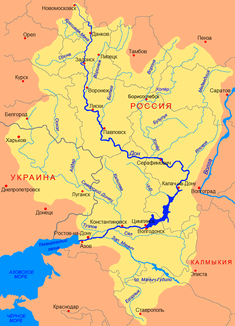
Location of the Sal in the catchment area of the Don |
||
The Sal ( Russian Сал ) is a left tributary of the Don in the south of the European part of Russia . Its length together with the longest headwaters of the Jurak-Sal river is 798 kilometers.
course
The left source river Dschurak-Sal des Sal arises from a multitude of small rivulets without a pronounced source at an altitude of 180 m in the Jergeni Hills in the west of the Republic of Kalmykia , a few kilometers west of its capital Elista . The Jergenihügel go in this area over the running east-west direction Sal-Manych back (Salsko-Manytschkaja grjada) above, from that of the south-flowing (Western) the basin of Sal Manytsch separates.
The Dschurak-Sal flows first in a north-westerly, then mainly in a northerly direction through dry steppe area ; After a few dozen kilometers it reaches the territory of Rostov Oblast , which it flows through in its further course to the mouth. Later it turns to the west, takes up the much shorter Kara-Sal ("Black Sal") from the right and is called Sal from there . The Sal maintains its westerly direction, roughly parallel to the Don in this section, up to its confluence with the latter, meandering increasingly strongly . The mouth is a few kilometers below Semikarakorsk , in a separate district. Near the mouth, the Sal is over 50 meters wide and 1.5 meters deep; the flow velocity is 0.1 m / s.
Its most important tributaries are Kara-Sal and Jerik from the right and Großer Gaschun (Bolshoi Gaschun, length 161 km), Kleine Kuberle (Malaja Kuberle, 152 km) and Große Kuberle (Bolschaja Kuberle) from the left.
In addition to Semikarakorsk near the mouth of the river, there are no other cities on the Sal, but there are a number of larger villages ( Selo ), including the district administrative centers of Remontnoye , Dubovskoye and Bolshaya Martynovka .
Hydrology
The catchment area of the river covers 21,300 km². The mean annual discharge 205 kilometers above the mouth is 9.9 m³ / s. The Sal freezes from around mid-December to the end of March, and the ice drift is irregular. In the upper reaches, the river can freeze to the bottom for up to 45 days in individual winters. In the dry summers, the upper and middle reaches of the river can dry out for up to 200 days.
Use and infrastructure
The Sal is not navigable.
The area through which the Sal flows almost everywhere for agriculture suffers from drought, so that its water is used for irrigation from the middle reaches . For this purpose, a series of canals was built that are fed by the Sal and its tributaries, such as the Upper Sal Canal (Verkhnesalski Canal) on the left (southern) side of the Saltal . Water from the Don, which is taken from the Zimljansker reservoir , is fed to the lower Sal via the Don Magistral Canal (Donskoi magistralny kanal) . The canal crosses the Sal with a trough bridge at Juschny , then runs roughly parallel to the river on the southern side and releases part of the water towards the Sal and part also towards the Manych.
The Sal is crossed by the Volgograd - Tichorezkaya - Krasnodar railway and by the branch line to Volgodonsk that branches off from this line at Krasnoarmeiski ( Kuberle station ) . The regional road network in the area is relatively dense. The river near the mouth crosses the road leading up the left bank of the Don towards Volgodonsk. Various roads leading into the eastern part of Rostov Oblast and towards the Kalmyk capital Elista also cross the river or follow its course in sections.
Individual evidence
- ↑ a b c Article Sal in the Great Soviet Encyclopedia (BSE) , 3rd edition 1969–1978 (Russian)
- ↑ Sal in the State Water Register of the Russian Federation (Russian)
