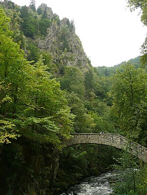
Maiden Bridge (Thale)
Coordinates: 51 ° 44 ′ 0 ″ N , 11 ° 1 ′ 4 ″ E
| Maiden Bridge | ||
|---|---|---|
| Jungfernbrücke with the Bode from the northeast | ||
| use | pedestrian | |
| Convicted | Hiking trail to La Viershöhe | |
| Crossing of | Bode | |
| place |
Thale - royal rest in the Bodetal |
|
| construction | Natural stone bridge on stone abutments | |
| location | ||
|
|
||
| Above sea level | 200 m above sea level NHN | |
The Jungfernbrücke in the Harz is a pedestrian bridge leading over the Bode in the Bodetal near the Thaler property in Königsruhe in the Harz district of Saxony-Anhalt .
Geographical location
The Jungfernbrücke is located in the Harz / Saxony-Anhalt Nature Park about 3 km southwest of the town center of Thale. It is located in the deeply cut Bodetal in the Hirschgrund a few meters east of the Königsruhe restaurant in the Königsruhe estate (approx. 200 m above sea level ) . Below the Roßtrappe ( 403 m ) it spans the Saale- tributary Bode , which is about 160 m east of the bridge at 198.9 m height.
history
overview
In 1904 the Jungfernbrücke was still a wooden structure. Later a bridge made of natural stone was built on stone abutments.
On December 30, 1925, during a flood in the Bode valley after the foehn and heavy snowmelt, the water level of the Bode rose to a level of 4.5 m above normal level. Severe flooding and damage occurred in the river valley. The bridge was torn away.
Today's bridge was built in 1927.
legend
According to a legend, only virgins are allowed to cross the Maiden Bridge so that it does not collapse. The innkeeper of the neighboring restaurant Königsruhe let a bell ring as soon as a maiden stepped on the bridge.
hike
A few meters north past the bridge in the Bodetal and through the Königsruhe property to the west of it, the European long-distance hiking trail E1 and the Harzer Hexenstieg ( Osterode am Harz –Harz – Thale) lead as part of a common section of the path . After crossing the bridge, a path branches off from these hiking trails and runs steeply in numerous serpentines through the Hirschgrund up to La Viershöhe ( 478.9 m ).
gallery
Individual evidence
- ↑ Saxony-Anhalt viewer of the State Office for Surveying and Geoinformation ( notes )
- ↑ Bridges in the Bodetal / Harz , Jungfernbrücke and other bridges, on ndtponton.wordpress.com
- ↑ a b Jungfern Bridge , information board photo, on commons.wikimedia.org


