Jurong (Zhenjiang)
The city of Jurong ( 句容 市 , Jùróng Shì ) is an independent city in the south-western part of Jiangsu Province in the People's Republic of China , which belongs to the administrative area of the prefecture-level city of Zhenjiang . Jurong has an area of 1,387 km². At the end of 2012 it had a registered population of 588,400 and a resident population of 622,200.
Jurong is located on the southern bank of the Yangtze River , about 45 kilometers from the provincial capital Nanjing , and Zhenjiang is also about 45 kilometers away. The climate is subtropical with an annual average temperature of 15 ° C and annual precipitation of 1000 mm. The relief is flat to hilly with some low mountains.
Jurong is on the Shanghai-Nanjing railway line and the Beijing-Shanghai highway . In addition, national roads 104 ( Beijing - Fuzhou ) and 312 ( Shanghai - Yining ) pass through the Jurong area. The city has a port on the Yangtze River and Qinhuai He . The nearest airport is Nanjing-Lukou Airport, approximately 35 kilometers away.
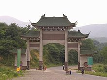
Attractions for visitors include the Baohua Shan , Mao Shan, and Chengtou Shan Mountains . The Maoshan Daoyuan , one of the most important Daoist temples in China, is located in Mao Shan . There are also numerous buildings from the time of the Tang , Song , Yuan , Ming and Qing dynasties , the Dingshadi site and a memorial to the fight of the New Fourth Army against the Japanese invasion in the Mao Shan Mountains.
Administrative structure
At the community level, the district is made up of three street districts and eight large communities. The city government is located in the Chongming Street District.
- Road quarter Huayang (华阳街道)
- Road quarter Chongming (崇明街道)
- Road quarter Huangmei (黄梅街道)
- Greater community Xiashu (下蜀镇)
- Greater community Baitu (白兔镇)
- Greater community Biancheng (边城镇)
- Greater community Maoshan (茅山镇)
- Greater community Houbai (后白镇)
- Greater community Guozhuang (郭庄镇)
- Greater community Tianwang (天王镇)
- Greater community Baohua (宝华镇)
Individual evidence
Coordinates: 31 ° 57 ' N , 119 ° 10' E
