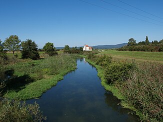
Kößnach (river)
|
Kößnach Kösnach |
||
|
Kößnach near Kößnach |
||
| Data | ||
| Water code | DE : 15762 | |
| location | District of Straubing-Bogen | |
| River system | Danube | |
| Drain over | Danube → Black Sea | |
| source | at Wiesenfelden -Kragenroth 49 ° 2 '2 " N , 12 ° 34' 30" O |
|
| Source height | approx. 645 m | |
| muzzle | at Straubing -Sossau in the Danube (confluence through river regulation) Coordinates: 48 ° 54 ′ 0 ″ N , 12 ° 34 ′ 19 ″ E 48 ° 54 ′ 0 ″ N , 12 ° 34 ′ 19 ″ E |
|
| Mouth height | approx. 315 m | |
| Height difference | approx. 330 m | |
| Bottom slope | approx. 17 ‰ | |
| length | 19.2 km | |
| Catchment area | 86.15 km² | |
| Left tributaries | Dreibrunnengraben | |
| Right tributaries | Cold ditch, excavator ditch, Falkenfelser Bach | |
| Communities | Wiesenfelden , Falkenfels , Kirchroth , Straubing | |
The Kößnach is a stream in the district of Straubing-Bogen , Lower Bavaria . It is one of the northern tributaries of the Danube in the Bavarian Forest .
course
It rises near Kragenroth in the municipality of Wiesenfelden and after about 1.5 km near the district of Roth it reaches the area of the municipality of Falkenfels . From the district of Stegmühl , the Kößnach marks the border between the communities of Wiesenfelden and Falkenfels. About 6.25 km after the source it takes on the Falkenfelser Bach . At km 7.3 km it reaches the municipality of Kirchroth . Originally the confluence with the Danube was in the Kößnach district of the Kirchroth community. In connection with the construction of the Straubing barrage , the mouth was relocated to the Sossau district of the city of Straubing . Through the diked Kößnach down trap with a length of 2.5 km, the water of the Kößnach is now guided parallel to the so-called Öberauer Donauschleife , an oxbow lake of the Danube, in an artificially created stream bed, and then below the Straubing barrage at river kilometer 2320.7 in to flow into the Danube.
Web links
Individual evidence
- ↑ Bavaria Atlas - map of the source area
- ↑ Bavaria Atlas - map of the estuary area
- ↑ a b List of brook and river areas in Bavaria - Danube river area from Naab to Isar. (PDF; 2.7 MB) Bavarian State Office for the Environment, accessed on April 20, 2014 .

