Ködnitzbach
| Ködnitzbach | ||
|
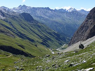
View from the north into the Upper Ködnitztal |
||
| Data | ||
| Water code | AT : 2-374-64-66-20-1 | |
| location | East Tyrol | |
| River system | Danube | |
| Drain over | Kalserbach → Isel → Drau → Danube → Black Sea | |
| source | at Ködnitzkees 47 ° 3 ′ 33 ″ N , 12 ° 41 ′ 16 ″ E |
|
| Source height | 2910 m above sea level A. | |
| muzzle | south of Ködnitz in den Kalserbach Coordinates: 46 ° 59 '52 " N , 12 ° 38' 33" E 46 ° 59 '52 " N , 12 ° 38' 33" E |
|
| Mouth height | 2295 m above sea level A. | |
| Height difference | 615 m | |
| Bottom slope | 75 ‰ | |
| length | 8.2 km | |
| Catchment area | 29.5 km² | |
| Left tributaries | Berger Bach, Peischlacbach, Folpremoabach | |
| Communities | Kals am Großglockner | |
The Ködnitzbach is a brook in the municipality of Kals am Großglockner ( Lienz district ). The stream rises on the Ködnitzkees and flows south of Ködnitz into the Kalserbach .
course
The Ködnitzbach rises south of the Ködnitzkees between the Stüdlhütte , Schere , Blaue Köpfe and Lange Wand. It first flows in a southerly direction, passes the Lucknerhütte and then the alpine pastures of several alpine pastures and the Lucknerhaus . In the lower reaches of the Ködnitzbach turns to the southwest, where it passes a forest valley and flows into the Kalserbach below Ködnitz.
Individual evidence
- ↑ a b TIRIS
- ↑ Office of the Tyrolean Provincial Government Dept. Environmental Protection (Ed.): Nature Conservation Plan of the Tyrolean River Areas. Classification of the river area-specific natural area potential. District: East Tyrol. Lienz 2004
- ↑ Federal Ministry of Agriculture, Forestry, Environment and Water Management (Ed.): Area directory of the Austrian river basins: Draugebiet. Contributions to the hydrography of Austria, issue No. 59, Vienna 2011, p. 9 ( PDF; 3.5 MB )
Web links
Commons : Ködnitzbach - Collection of images, videos and audio files
