
King Ludwig route


The König-Ludwig-Trasse (KLT) is a former railway line in the Ruhr area in the cities of Castrop-Rauxel and Recklinghausen , which connected the mines König Ludwig I / II and IV / V with the coal loading port on the Rhine-Herne Canal in Pöppinghausen. The 2.5 km stretch from the port to Orthlohstraße has been expanded as a walkway and cycle path and was released on this section in December 2008. The route is to be rededicated to its end at the Blumenthal dump in Oer-Erkenschwick .
history
In 1885, a connection between King Ludwig I / II and the railway connection in Recklinghausen was established. This was later extended to the north to the König-Ludwig IV / V colliery in Suderwich (now part of Recklinghausen). With the construction of the branch canal to the Dortmund-Ems canal from Henrichenburg to Herne (today part of the Rhine-Herne canal), the route was extended south to the port of König-Ludwig. There were two extensive storage areas for coal and coke with a large portal crane system for loading them onto canal ships. The route was also used to transport miners between the mines. The former state shipyard north of the Herne-Ost canal lock was also connected from the canal port . In the north, the route can be traced to the Blumenthal-Haard mine in Oer-Erkenschwick.
The mines themselves were closed in 1963 and 1965. During the dismantling of the pits, the material was transported over the railway line. Remnants of the railway were shut down and dismantled in the 1990s.
The KLT bike path
The RVR acquired KLT land and renovated the bridges over several streets and the Emscher. The first construction phase is equipped with a water-bound surface. The access from the Rhein-Herne-Kanal-Radweg (north side) leads over the former storage areas, some of which are used today for parking / wintering of the AMC Castrop Rauxel's leisure ships. The AMC uses the harbor as a pleasure boat harbor.
Since the railway line between the port and the former colliery I / II was led on a high embankment, you have a good overview of the middle Emschertal, which is rural in character. The bridges over Pöppinghauser Strasse, Merveldtstrasse and over the Emscher have been extensively renovated. A ramp has been set up at the Emscher Bridge, which enables access to the Emscher Cycle Path . The route is well signposted; Royal blue steles clearly mark the way.
The embankment flattens out in front of the König-Ludwig mine. Railway tracks bear the designation of the entrances and in the area of the colliery there is a station with a route extension and a mine locomotive . Seating has been arranged in several places. In front of Ortlohstraße you pass the concrete coal loading station of the mine, next to which there is still a rusty water tank.
Further construction phases
The next construction phase with a length of 6 km extends from Ortlohstraße over the existing bridge over the A2 motorway to Becklemer Busch. The bridge over the freight train route had been dismantled and must be rebuilt.
The last construction phase is to lead to the Blumenthal dump in Oer-Erkenschwick. The total length of the route will then be 14 kilometers.
With the König-Ludwig-Trasse, the network of cycle paths in the Ruhr area is concentrated . After the completion of the project, the 100-Schlösser-Route and thus the southern Münsterland can be reached from the Westpark in Bochum via the Erzbahntrasse , the Emscher-Weg or the cycle path on the Rhine-Herne Canal and the König-Ludwig-Trasse .
The next construction phase between Ortlohstrasse and Sachsenstrasse was opened on June 13, 2018.
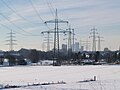
View into the Emschertal to the west

The Hoheward dump

Rest area with route expansion
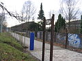
Entry into the cycle path at the level of the former colliery


Individual evidence
- ↑ http://www.ruhrnachrichten.de/lokales/castrop/Teil-eins-der-Koenig-Ludwig-Trasse-eroeffnet;art934,435230 Article in the Ruhr Nachrichten
Coordinates: 51 ° 34 ′ 5.5 ″ N , 7 ° 15 ′ 30.5 ″ E