
Königsberg Pregelbrücken


The Königsberg Pregelbrücken lead in Königsberg (Prussia) over the two arms of the Pregel . They became known through the Königsberg bridge problem , which was treated by Leonhard Euler in 1736 .
history
The first bridges in Königsberg were swing, gate or bascule bridges. If a ship wanted to cross the low bridge, the bridge had to be laboriously opened. This cost effort and time and thus slowed down trade in the always hectic port area around the Kneiphof. In 1853, Königsberg was connected to Berlin by rail. This also brought the achievements of the technical revolution to the East Prussian metropolis on the Pregel. Small handicraft businesses such as the Union Foundry quickly developed into medium-sized and large industrial companies and thus created the conditions for the industrialization of the country.
On May 26, 1881, the Königsberg Horse Railroad Company opened the first horse tram and on May 31, 1895 the first city electric tram . Now the problem arose, however, that a wooden bridge cannot hold the track for a tram as well . Therefore, from 1891 to 1912, all bridges in Pregelstadt were converted to industrial bascule bridges. The material as well as the technology was developed by the Union foundry in Königsberg . The overhead line of the trams was led to the middle of the bridge and attached to an upper rod running across the street. Therefore, the overhead line for the tram was not interrupted when the bridge was closed, and when the bridge was opened, the overhead lines did not constitute an obstacle to shipping with their sometimes towering masts. Thanks to the new folding technology, not only could the trams use the bridges, but the interval times between opening and closing were also reduced enormously. The bridges were no longer such an obstacle and traffic from different parts of the city, be it by water or by road, could be faster and smoother. However, in Königsberg city traffic, the bascule bridges still represented a residual imputed uncertainty. So it was a popular excuse of the Königsberg students to blame a high bridge for being unpunctual.
Kneiphof

Königsberg lies on the northern new Pregel and the southern old Pregel. The Pregelarme form the Kneiphofinsel . Both pregel arms reunite at the dog husband. The river flows into the Fresh Lagoon and thus into the Baltic Sea . In this way, Königsberg combined inland shipping and maritime shipping . Around the Kneiphof was the old port of the city. A wide variety of ships and land vehicles landed on this island. That is why all Kneiphof bridges were built as bascule bridges.
Green bridge
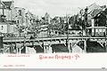
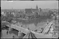
The Green Bridge connected the northern suburb with the southern Kneiphof. From the suburban Langgasse you crossed the Green Bridge to the Green Gate (which was demolished in 1864) . This is where the Kneiphöfische Langgasse, the magnificent main street of Kneiphof, began. On the right side was the old stock exchange at the Green Gate . The Green Bridge, like the Köttel Bridge, spanned the New Pregel and was thus one of the wide Kneiphof bridges, where the folding mechanism had to be extended with a bridge feeder. Built in 1322, it burned down in 1582 and was replaced by a new building in 1590. This crank bridge remained in place until 1907. Then bascule bridge . The Green Bridge was famous and was often photographed. She did not survive the Second World War . In its place, a 546 m long and 27 m wide elevated road made of prestressed concrete was built over the two arms of Pregel and the island in 1972 .
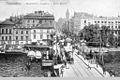
Green bridge with Kneiphöfscher Langgasse

The old Green Bridge with a view of the Lastadie
The old green bridge

The stock exchange with the Green Bridge in the foreground

The "New" Green Bridge at the inauguration in 1907
The New Green Bridge

Green bridge with stock exchange

Green bridge seen from the stock exchange
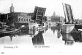
Green bridge when open


Krämerbrücke
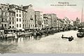
The Krämerbrücke connected the northern Kneiphof with the southern old town. It took you from Kneiphöfschen Langgasse to Kantstrasse, which led to Kaiser-Wilhelm-Platz, the lively traffic junction at the foot of the castle. From the Krämerbrücke you could see the hustle and bustle on the Lastadie or overlook the Lower Fish Market on the other side. The old bridge construction did not survive the Second World War. This bridge, together with the Green Bridge, was replaced in 1972 by a 546 m long and 27 m wide elevated road made of prestressed concrete over the two arms of the Pregel and the island.
The old Krämerbrücke ...

... was replaced by the new one

The new bridge

Krämerbrücke with ship

The Krämerbrücke with a view of Kantstrasse and the castle

Mood picture Krämerbrücke / Fischmarkt

new prestressed concrete bridge over the Pregel replaces the Green Bridge and the Krämer Bridge


Forge bridge
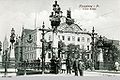
The cathedral bridge was built east of the later forge bridge in 1330. It connected the northern Kneiphof with the southern old town. After the old townspeople and the Kneiphöfer had built the forge bridge, the cathedral bridge was demolished. From Schöneberger Straße you got over the Krämerbrücke to Schmiedestraße. The forge bridge was renewed in 1787 and rebuilt as a bascule bridge in 1896 . The bridge did not survive the Second World War. Only the foundations on both river banks can be seen.

The forge bridge
Lower fish market
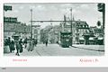
Forge bridge with tram

Bridge house


Köttelbrücke
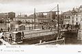
First built in 1377, the Köttelbrücke connected the northern suburb with the southern Kneiphof. From Schnürlingsstraße you crossed the Green Bridge to Köttelstraße of the Kneiphof. Like the Green Bridge , it spanned the Old Pregel. It was one of the wide Kneiphof bridges, where the folding mechanism still had to be extended with a bridge feeder. It was rebuilt in 1886 as a bascule bridge . This bridge also did not survive the Second World War and was not replaced.

Köttelbrücke

Open bridge
View upstream


Honey bridge
The Honigbrücke or Dombrücke connects the Lomse with the eastern Kneiphof. From Lindenstrasse you got to Pauperstrasse over the Honigbrücke bridge. Completed in 1542, it was named after the honey barrels with which the Oberburggraf Besenrade bribed Kneiphöfer councilors. The old town citizens are said to have angrily called the Kneiphöfer only the “honey lovers”. The bridge was the only Kneiphof bridge to survive the Second World War and can still be viewed today.

The honey bridge was one of the few to "survive" the war.

The honey bridge today

The folding mechanism is no longer functional


Lomse
Between the Old Pregel and the New Pregel, another extensive river island stretches east of the city, the then Lomse. Originally the city meadows were located here, and it was not until the late 19th century that individual industrial companies settled. The most imposing buildings are likely to have been the New Synagogue and the Kreuzkirche . The following bridges led to the Lomse:
Wooden bridge
The wooden bridge connected Löbenicht with the Lomse. From the upper fish market one got over the wooden bridge to the Lindenmarkt. The bridge survived World War II and still exists today; but not as a bascule bridge.
The wooden bridge

The wooden bridge (1935)

old and new wooden bridge
The wooden bridge in the unfolded state

The wooden bridge

The wooden bridge

The wooden bridge

The wooden bridge
The new wooden bridge


High bridge
The Hohe Brücke connected the eastern Haberberg with the Lomse, that is, the Brückenstraße with the Weidendamm. A bridge had existed at this point since around 1520. Between 1882 and 1883 the Hohe Brücke was built as a drawbridge by the city's building inspector Richter. The bridge house, in which the mechanical opening device is housed, was also created. In 1937 it was torn down down to the stone pillars and replaced by a new building right next to the old bridge. The opening mechanism of this new bridge is still operational. In 2009, the bridge was restored for around seven million rubles (about 240,000 euros) and the load-bearing capacity increased to 30 tons.

High Bridge, Koenigsberg

High bridge

High Bridge, Kaliningrad


Kaiserbrücke
The Kaiserbrücke was, as the name suggests, the time of the Konigsberg bridge problem is not existent. It connected the eastern suburb with the Lomse. From Kaiserstraße you got to Weidendamm over the Kaiserbrücke. The bridge was badly damaged in World War II and subsequently fell into disrepair. As part of the city's 750th anniversary in 2005, it was largely reconstructed true to the original and is now called the Jubilee Bridge. It only serves as a pedestrian bridge.

The old Kaiserbrücke

The old Kaiserbrücke
The foundations of the destroyed Kaiserbrücke, photo from 1992

The Jubiläumsbrücke (Kaiserbrücke) today


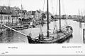
port
Railway bridge
The railway bridge on the Holländerbaum was the first steel bridge in Königsberg . The locality was called Holländerbaum because in ancient times a customs tree was erected here, where seagoing ships had to pay customs when entering the port. The Lastadie am Hundegatt was the old port of the Hanseatic city. But by the end of the 19th century, more and more companies and shipyards settled on the southern lower reaches of the Pregel. A connection between the south and east stations, the former Pilau station, also had to be created. This made a bridge connection at the lower reaches of the Pregel necessary. In 1862 the Prussian government decided to build it. The state assumed the cost of 385,000 thalers. From 1863 to 1865, the masonry river pillars in the Pregel were lowered. The first bridge was built in 1884. The first railroad crossed the bridge on October 1st, 1889. As a major innovation, the bridge had a toggle mechanism instead of the usual screw jack. The bridge was decommissioned in 1929 with the construction of the new Reichsbahnbrücke, but was retained for disaster control measures. The bridge was rebuilt as a lifting bridge after the Second World War and is now out of service.

The railway bridge in Koenigsberg

Old railway bridge in Koenigsberg

The railway bridge was rebuilt as a lifting bridge, now partially dismantled


Reichsbahnbrücke
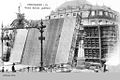
The simple railway bridge with a bascule bridge for shipping soon no longer met the requirements. Above all through their prudent and skillful Lord Mayor Dr. Hans Lohmeyer left the city of Königsberg, after the World War II and the separation of East Prussia from the Reich, no stone unturned in modernizing and maintaining or promoting the economy and trade. The entire rail network was modernized and the Reichsbahnbrücke started in 1913 and built as a double-decker swing bridge in 1926 after 13 years of construction . It crossed the Pregel west of the fortress Groß Friedrichsburg for the routes to Pillau and Tilsit . The basement of the bridge carried a 7 m wide street with two tram tracks and two pedestrian paths. Four tracks ran on the upper floor. During commissioning, however, it turned out that the roadway was too narrow due to the heavy vehicle traffic, which meant that the two tram tracks could never be put into operation. A span of 42.5 m between the end piers of the approximately 200 m long bridge. The two-armed swing bridge with a length of 2 × 28.7 m opened up a ship passage of 2 × 17.5 m. The building material was refined mild steel with a weight of 1225 t. The bridge was considered a technical marvel. The bridge was badly damaged in the Second World War and then rebuilt as a lifting bridge .

The new Reichsbahnbrücke in Königsberg

Today's bridge as a lifting bridge

North tower of today's bridge


Palmburger Autobahn bridge
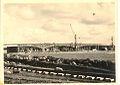
The motorway bridge was built in 1938 near Palmburg, southeast of Königsberg. It was part of the planned Reichsautobahn Berlin – Königsberg . As a whole, the four-lane road bridge spanned the old and new Pregel with two bridge arms of 633 m each . It was the longest reinforced concrete bridge in the German Empire. When the East Prussian Operation began (1945) , it was blown up by Wehrmacht pioneers. The conquest of Konigsberg by the Red Army is unlikely to have been delayed as a result; because the bridge did not lead to the city, but south of the city in a north-south direction over the Pregel. Nevertheless, it was not taken until April at the Battle of Koenigsberg . In the 1970s, one side of the road was restored, the other remained unchanged. The bridge became more and more of a bottleneck for traffic. The destroyed Palmburger Brücke (or Berliner Brücke) served as the backdrop for the Soviet feature film Handshake on the Elbe . After being in ruins for over 60 years, the bridge arches have been removed since 2014. A new one is to be built on the pillars of the old bridge. Today the (half) bridge connects Pribreschnoje (Kaliningrad, Gurjewsk) and Rschewskoje (Kaliningrad) .
The Palmburger Bridge under construction in 1938

The Palmburger Bridge as it was seen until recently


literature
- Robert Albinus: Königsberg Lexicon. City and surroundings. Special edition. Flechsig, Würzburg 2002, ISBN 3-88189-441-1 .
- Richard Armstedt : history of the royal. Capital and residence city of Königsberg in Prussia. (= German land and life in individual descriptions. 2, city stories). Hobbing & Büchle, Stuttgart 1899. (Reprint: Melchior-Verlag, Wolfenbüttel 2006, ISBN 3-939102-70-9 ( Historical Library )).
- Fritz Gause : The history of the city of Königsberg in Prussia. 3 volumes. 2nd / 3rd, supplemented edition. Böhlau, Cologne et al. 1996, ISBN 3-412-08896-X .
- Jürgen Manthey : Königsberg. History of a world citizenship republic. Hanser, Munich et al. 2005, ISBN 3-446-20619-1 .
- Gunnar Strunz: Discover Königsberg. On the way between Memel and Haff. (= Trescher series of trips ). Trescher, Berlin 2006, ISBN 3-89794-071-X .
- Museum of the City of Königsberg (ed.): The Köttelbrücke, iron bascule bridge in Königsberg i.Pr. Pictorica, Kaliningrad 2013 ( online ).
Individual evidence
- ^ Robert Albinus: Königsberg Lexicon . Würzburg 2002, p. 67.
- ↑ Palmburger Bridge will be removed - ostpreussen.de
- ↑ New construction of the Berliner Brücke opened - ostpreussen.de
Coordinates: 54 ° 42 ′ 24.5 ″ N , 20 ° 30 ′ 22.6 ″ E