Křížový vrch (Broumovská vrchovina)
| Křížový vrch | ||
|---|---|---|
|
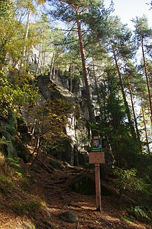
View from the northwest to the Křížový vrch |
||
| height | 666.8 m nm | |
| location | Czech Republic | |
| Mountains | Broumovská vrchovina | |
| Coordinates | 50 ° 37 '29 " N , 16 ° 7' 42" E | |
|
|
||
| rock | Ashlar sandstone | |
| particularities | Climbing area | |
The Křížový vrch , colloquially Křížák , (German Holsterberg ) is a wooded table mountain with a small rock town in the northwest of the Broumovská vrchovina ( Braunauer Bergland ) in the Czech Republic . He is on the district Dolní Adršpach the municipality Adršpach in náchod district in the Czech Republic.
geography
The Křížový vrch is located one kilometer northeast of Dolní Adršpach and southwest of Zdoňov . In the north, the mountain is surrounded by the Hrnčířský potok and in the east by the Zdoňovský potok; to the south, the Metuje valley separates it from the Adršpach-Wekelsdorfer Felsenplatte .
To the north rises the Kopeček ( Small Mountain , 587 m nm), in the northeast the Družstevní vrch ( Rauchersberg , 613 m nm), southeast the Lada ( heather , 623 m nm), in the south the Bučina ( Buchberg , 604 m nm), southwest of the Starozámecký vrch ( Althausberg , 681 m nm) and in the northwest of the Šibeniční vrch ( Galgenberg , 632 m nm).
description
The rock slab of Křížový vrch is divided into the northern main plateau ( Zdoňovský oblouk ), the ridge ( Křížový hřeben ) and the south towers ( Jižní věže ); in between, the central gorge ( Centrální rokle ) protrudes into the plateau from the east .
The rock walls on Křížový vrch are a climbing area in which over 200 rocks and towers with over 1550 paths are described today. The climbing area also includes the rocks on the Lada with 23 rocks and 87 described paths as part of the Zdoňovská Hejda ( Merkersdorfer Heide ) sub-area ; the difficulty scale of the routes ranges from simple paths in isolated cases to Xb. The most famous climbing peak is the Maják tower .
The entire summit area of Křížový vrch has been under protection since 1956 on an area of 13.7 hectares as the Křížová cesta nature reserve (originally called the Rozsochatec nature reserve).
The steeply ascending Way of the Cross , which was laid out in the 17th century, branches off from the yellow-marked hiking trail between Adršpach and Zdoňov that runs west of the mountain . The stations of the route are cast-iron, partly polychromed , bas-reliefs set into the rocks. At Maják , the Way of the Cross reaches the main plateau, where it stands on an iron cross built in 1857 on a high sandstone base in which the figures of St. Anna, Josef and Johannes von Nepomuk are incorporated. The Way of the Cross, which today gives the mountain its name, has been protected as a cultural monument of the Czech Republic since 2008. From the viewpoint above the Maják there is a view in northerly directions to the Czech-Polish border ridge with the Albendorfer Heide ( Hraniční hřbet ), Schömberger Heide, Raspenauer Heide and the Oberwald ( Mirošovské stěny ). The mountain summit 150 m east of the viewpoint is not accessible.
In the pottery grounds ( Hrnčířské údolí ) north of the mountain is the chapel of St. John of Nepomuk.
history
It is believed that the forest on the Holsterberg has been used for forestry since the area was settled in the 13th century. In the 17th century, the owners of the Adersbach lordship had the Way of the Cross, which branches off the church path from Adersbach to Merkelsdorf, built on the mountain. At the upper exit of the Way of the Cross a cast iron cross was erected on a high sandstone base in 1857.
At the beginning of the 20th century the mountaineering development of the Holsterberg began; Georg Richter and Rudolf Glatzer climbed the striking rock on the Way of the Cross and named it Waldblößenturm . For a long time it was the focus of climbing activities on the Holsterberg, in the following years several new paths were opened up. In 1935 Wilhelm Taubert, Edmund Oehme and Hellmuth Rieger climbed the Outer Tower ( Ústecký věž ) for the first time . After the Second World War and the expulsion of the German population, rock climbing on Křížový vrch also came to a standstill, but was resumed in 1949. In 1957 František Čepelka and Rudolf Ziedler climbed the cross tower ( Křížová věž ) for the first time .
Web links
Individual evidence
- ↑ peaks and trails on www.horosvaz.cz
- ↑ Description of the climbing area on www.piskari.cz
- ↑ Křížová cesta nature reserve
- ↑ křížová cesta ÚSKP 102957 in the monument catalog pamatkovykatalog.cz (Czech). Catalog number 1331496128.


