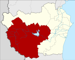
Kaeng Krachan district
|
Kaeng Krachan แก่ง กระจาน |
|
|---|---|
| Province: | Phetchaburi |
| Surface: | 2500.478 km² |
| Residents: | 30,262 (2013) |
| Population density : | 11.1 U / km² |
| ZIP : | 76170 |
| Geocode : | 7608 |
| map | |

|
|
Kaeng Krachan District ( Thai : อำเภอ แก่ง กระจาน ) is a district ( Amphoe - administrative district) of Phetchaburi province . Phetchaburi Province is located in the southwestern part of the central region of Thailand .
geography
Neighboring districts are (from north clockwise): Amphoe Nong Ya Plong , Ban Lat and Tha Yang in Phetchaburi Province, Amphoe Hua Hin of Prachuap Khiri Khan . To the west lies the Tanintharyi Division of Myanmar .
Most of the county is occupied by the forested hills of Kaeng Krachan National Park. The sources of the Phetchaburi River and the Pranburi River are in this area.
Kaeng Krachan County is one of the lowest population counties in Thailand.
history
Kaeng Krachan was first established on January 1, 1988 as a "branch circle" ( King Amphoe ) by separating the area from Amphoe Tha Yang . On November 3, 1993, he was raised to full amphoe status.
Attractions
- Kaeng Krachan National Park (Thai: อุทยานแห่งชาติ แก่ง กระจาน ) - Thailand's 28th National Park opened on June 12, 1981. At 2914.7 km² it is the largest park in terms of area. Numerous species of butterflies and birds as well as some waterfalls are worth seeing.
administration
Provincial Administration
Kaeng Krachan County is divided into six tambon ("subdistricts" or "parishes"), which are further divided into 52 muban ("villages").
| No. | Surname | Thai | Muban | Pop. |
|---|---|---|---|---|
| 1. | Kaeng Krachan | แก่ง กระจาน | 14th | 8,044 |
| 2. | Song Phi Nong | สองพี่น้อง | 8th | 4,844 |
| 3. | Wang Chan | วัง จันทร์ | 8th | 5,064 |
| 4th | Pa Deng | ป่า เด็ ง | 10 | 5,463 |
| 5. | Phu Sawan | พุ สวรรค์ | 6th | 3,358 |
| 6th | Huai Mae Phriang | ห้วย แม่ เพรียง | 6th | 3,489 |
Local administration
In the district there are six " tambon administration organizations " ( องค์การ บริหาร ส่วน ตำบล - Tambon Administrative Organizations, TAO)
- Kaeng Krachan (Thai: องค์การ บริหาร ส่วน ตำบล แก่ง กระจาน ) consisting of the complete tambon Kaeng Krachan.
- Song Phi Nong (Thai: องค์การ บริหาร ส่วน ตำบล สองพี่น้อง ) consisting of the complete Tambon Song Phi Nong.
- Wang Chan (Thai: องค์การ บริหาร ส่วน ตำบล วัง จันทร์ ) consisting of the complete tambon Wang Chan.
- Pa Deng (Thai: องค์การ บริหาร ส่วน ตำบล ป่า เด็ ง ) consisting of the complete tambon Pa Deng.
- Phu Sawan (Thai: องค์การ บริหาร ส่วน ตำบล พุ สวรรค์ ) consisting of the complete tambon Phu Sawan.
- Huai Mae Phriang (Thai: องค์การ บริหารส่วน ตำบล ห้วย แม่ เพรียง ) consisting of the complete tambon Huai Mae Phriang.
Individual evidence
- ↑ ประกาศ กระทรวง มหาดไทย เรื่อง แบ่ง เขต ท้องที่ อำเภอ ท่ายาง จังหวัด เพชรบุรี ตั้ง เป็น กิ่ง อำเภอ แก่ง กระจาน Royal Gazette, Vol. 105, Ed. 5 ง , January 7, 1988, p. 110 (in Thai)
- ↑ พระราชกฤษฎีกา ตั้ง อำเภอ ลำ ทับ อำเภอ ร่องคำ อำเภอ เวียง แหง อำเภอ นา โยง อำเภอ แก้ง สนาม นาง อำเภอ โนน แดง อำเภอ บ้านหลวง อำเภอ กะพ้อ อำเภอ ศรี บรรพต บรรพต อำเภอ แก่ง กระจาน อำเภอ อำเภอ หนอง สูง อำเภอ สบ เมย อำเภอ เมย วดี อำเภอ โคก เจริญ อำเภอ ทุ่งหัวช้าง อำเภอ วัง ขาว ขาว ขาว ขาว ขาว ขาว หิน อำเภอ ดอนพุด อำเภอ บึง โขง หลง และ อำเภอ ห้วย ค ต พ.ศ. ๒๕๓๖ Royal Gazette, Vol. 110, Ed. 179 ก special ( ฉบับ พิเศษ ), November 3, 1993, pp. 1–3 (in Thai)
- ↑ 2013 population statistics ( Thai ) Department of Provincial Administration. Retrieved September 11, 2014.
Web links
- More information about Amphoe Kaeng Krachan from amphoe.com (in Thai)
- Information about the Kaeng Krachan National Park (in English)
Coordinates: 12 ° 54 ' N , 99 ° 39' E

