Kagenow
Kagenow is a village in the Vorpommern-Greifswald district . It is part of the community of Neetzow-Liepen . The place is about 1.8 km north of the federal highway 110 and 1.3 km south of the Peene , to the west runs the large ditch.
history
Kagenow was first mentioned in 1307 as Kaghenowe . Kagenow is a Slavic foundation and means something like "pine bush". The current name was used as early as 1353.
Kagenow was on the medieval trade route from south to north or vice versa via the regionally important ferry from Kagenow to Gützkow over the Peene. It was here that the Great Elector crossed the Peene during the campaign against Swedish Pomerania in 1675. Around 1880 Kagenow had the form of a manor village with the manor and the farm workers' catenary as well as the church at the manor.
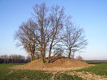
With its soil monuments in the area, such as Bronze Age barrows, Slavic ramparts and early German tower mounds, one can conclude that there was an early and continuous settlement. Kagenow was an estate village that was shaped by the estate and its farm workers' cottages. But it also had a farming village part. In modern times, settlement courtyards emerged.
In 1326 the village had two estates, that of knight Martin von Winterfeld and that of knight Klaus Heyden, the latter with the Heyden from Kartlow . Heyden had built a castle on the border with Priemen not far from the Peene, this place is now called the "Schlossberg". The Winterfeld probably had their first seat on the tower hill castle "Judenberg" (why this is called that is unclear) and later in the manor house near the church. Both gentlemen were allowed to judge “ hand and neck ” on the nearby “judicial mountain” .
The Heyden family sold their share in Kagenow in 1419 to the Netzow family. After the inheritance disputes in the von Winterfeld family from 1709 to 1724, their share was also sold to Rittmeister Bernd Ludwig Netzow. With that he owned the whole village, except for the farmer's share. Ludwig von Netzow sold the property to Wilhelm von Kruse auf Neetzow in 1842.
In 1865 the part of the village had 1 church, 1 sexton's house, 1 school, 1 manor house, 8 residential houses and 12 farm buildings. The manor village had 112 inhabitants. The farming village part had 4 houses, 3 farm buildings and 1 blacksmith shop, there were 21 residents there, 1 family in the blacksmith shop and 2 in the farms, plus the servants and maids.
In 1940 the so-called Kiessee von Kagenow was created through intensive dredging , where the gravel was extracted for the construction of the Wehrmacht airfield in Tutow. Tombs of Brandenburg soldiers from the war of 1675 were found here, and skeletons of the killed horses were also found. The dating was based on parts of the uniform (e.g. buttons and weapons). The lake that was created was later a popular swimming area for the villages south of the Peene. A holiday camp was set up next to the fisherman's house Kagenow on the Peene.
On July 1, 1950, the municipality of Kagenow was incorporated into Neetzow.
Attractions
→ See also the list of architectural monuments in Neetzow-Liepen
- Kagenow Church
- Tower hill “Judenberg” south of Kagenow church
- Castle ramparts "Schanzberg" Kagenow
- Kiessee near Kagenow
- Richtberg , Bronze Age barrow between Kagenow and Priemen - belongs to the district of Liepen
literature
- Manfred Niemeyer: East Western Pomerania. Collection of sources and literature on place names. Vol. 2: Mainland. (= Greifswald contributions to toponymy. Vol. 2), Ernst-Moritz-Arndt University of Greifswald, Institute for Slavic Studies, Greifswald 2001, ISBN 3-86006-149-6 . Pages 88, 93, 100, 127
- Heinrich Berghaus : Land book of the Duchy of Pomerania and the Principality of Rügen. Part II, Volume 1, Anklam 1865 ( online )
Individual evidence
- ^ Manfred Niemeyer: Ostvorpommern . Collection of sources and literature on place names. Vol. 2: Mainland. (= Greifswald contributions to toponymy. Vol. 2), Ernst-Moritz-Arndt-Universität Greifswald, Institute for Slavic Studies, Greifswald 2001, ISBN 3-86006-149-6 , p. 57.
- ^ Heinrich Berghaus : Land book of the Duchy of Pomerania and the Principality of Rügen . Part II, Volume 1, Anklam 1865, pp. 320–322 ( online )
- ↑ Federal Statistical Office (Ed.): Municipalities 1994 and their changes since 01.01.1948 in the new federal states. Metzler-Poeschel, Stuttgart 1995, ISBN 3-8246-0321-7
Web links
Coordinates: 53 ° 54 ' N , 13 ° 25' E

