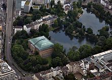
Kaiserteich
| Kaiserteich | |
|---|---|

|
|
| Kaiserteich with Ständehaus | |
| Geographical location | Unterbilk , Düsseldorf , North Rhine-Westphalia , Germany |
| Tributaries | Inner southern Düssel |
| Drain | to the swan mirror |
| Data | |
| Coordinates | 51 ° 13 '2.3 " N , 6 ° 46' 26.1" E |
| length | 150 m |
| width | 120 m |

|
|
| City map 1854 / building and leveling plan for the expansion of the city of Düsseldorf | |
The Kaiserteich in Düsseldorf-Unterbilk is one of the bodies of water that emerged from the original protective waters of the Düsseldorf fortifications after it was razed in 1802. With the swan mirror to the north, it forms a double pond , to which it is only connected by a narrow, bridged water connection. The double pond is bordered by a park based on the concept of the English landscape garden .
location
The body of water lies between Elisabethstrasse in the east and the waterway in the west. To the north is the Schwanenspiegel with Haroldstrasse and to the south are the Ständehaus and Ständehausstrasse . The river flows through and is fed with water from the southern Düssel .
history
Since both Schwanenspiegel and Kaiserteich with the associated park areas were created at the same time from 1842, the story for both ponds is identical. In the city map from 1854, Düsseldorf is shown with its waters after the new parks were laid out. This representation differs from the current situation in many areas, but shows the location and extent of the water bodies mostly up to date. Changes arose primarily in the course of urban expansion and urban development in the 19th century as well as the construction and widening of streets in the 19th and 20th centuries. In 1842, for example, Graf-Adolf-Platz and the districts of Friedrichstadt and Stadtmitte were not yet available. The area between Kasernenstrasse and Königsallee, used by the military as a parade ground and for barracks , still existed.
The "Lohhof" was originally located on the southern bank and was bought by the city of Düsseldorf in 1869 along with its entire site. In 1875 large parts of this area were made available by the city free of charge to the Provincial Association of the Rhine Province . The Ständehaus was built on this site to replace the premises of the Provincial Parliament of the Rhine Province, which previously had its domicile in the Düsseldorf Palace , which burned down in 1872 .
Individual evidence
- ↑ a b Topographical Information Management, Cologne District Government, Department GEObasis NRW ( Notes )
- ^ Digitized edition of the ULB Düsseldorf Düsseldorfer Geschichtsverein: Festschrift for the 600th anniversary of Düsseldorf , p. [397] 380.
- ^ Düsseldorf / Statistisches Amt, in: Report on the status and administration of community affairs , 1861-1914, p. [4] 2. Online version
