
Haroldstrasse
| Haroldstrasse | |
|---|---|
|
|
|
_Postkarte_von_1908.jpg) |
|
| Haroldstrasse with Düsseldorf Synagogue (right) postcard from 1908 | |
| Basic data | |
| place | Dusseldorf |
| District | Carlstadt , Unterbilk |
| Created | 1831 |
| Connecting roads | Kavallariestraße Neusser Straße |
| Cross streets | Schwanenmarkt , Poststrasse, Horionplatz with Berger Allee |
| Places | Graf-Adolf-Platz , Johannes-Rau-Platz |
| use | |
| User groups | Pedestrian traffic , bicycle traffic , car traffic , public transport |
The Harold Street is located on the southern edge of the district Carlstadt in the North Rhine-Westphalian state capital Dusseldorf . It begins in the east at Graf-Adolf-Platz and runs from there to the banks of the Rhine, where it ends at Johannes-Rau-Platz or merges into Neusser Straße .
Location and history
In 1831 a development plan was drawn up, according to which Haroldstrasse was created between Berger Allee and Schwanenspiegel . The street was formally established on June 4, 1831 and named after the royal Bavarian major general Edmund von Harold , who had the first house built in the area of the street. Initially, only the section between Poststrasse and Kasernenstrasse was called Haroldstrasse and it was not until 1843 that it was extended westward to Berger Allee .
In 1838, Düsseldorf's first train station was laid out at the southern end of Königsallee for the Düsseldorf-Elberfelder Eisenbahn-Gesellschaft and opened in December of the same year. A siding later led from this station in the direction of the Rhine to what would later become Berger Hafen and was connected to the port railway tracks there. Haroldstrasse was also extended to the banks of the Rhine.
The then still narrow street was parallel to the railway line. In 1841, Haroldstrasse was extended eastward beyond Kasernenstrasse to the train station, and a pond between the city moat and the train station was filled in. At that time, the moat was still connected to the swan mirror via an open moat. The complete vaulting of this open Düssel connection with the laying underground was carried out during the extension of Haroldstraße to the end of Königsallee in 1856.
At the end of the 1880s, new track systems for the railway connection to the existing Hammer Railway Bridge were laid out about 1.5 km further east in the city with a south-westerly arch towards the Rhine in order to be able to close the stations at the southern end of Königsallee. In 1891 the new central station was opened and then the old stations were demolished. As part of the Stübben plan, the Haroldstrasse - Graf-Adolf-Strasse street was reorganized. A new clay pipeline was laid to Poststrasse in 1891 to drain the main post office at Haroldstrasse at the corner of Kasernenstrasse .
This was followed in 1892 and 1893 by the expansion of Haroldstrasse using the disused railway line to form a wide avenue with a double track system for a horse-drawn tram and a central promenade from the end of Königsallee to Neusserstrasse. This new tram connection could only be put into operation a little later after the expansion of Kavallariestrasse. An extension of the tram to Stromstraße and the end point at Zollhof followed when the new port facilities were built on Lausward in the late 1890s. Forty-four new linden trees were also planted for the avenue.
.jpg)
At the meeting of the 49th Rhenish Provincial Parliament on March 12, 1909, the city of Düsseldorf decided to buy a plot of land at the western end of Haroldstrasse, between Berger Allee and Berger Ufer , bordered to the north by Thomasstrasse. After the purchase, a building for the administration of the Rhine Province and the Villa Horion as the official residence of the governor were built on this property .
From 1933 to 1945 the street was renamed Adolf-Hitler Straße. The eastern area of the street from the junction of Kasernenstrasse / Elisabethstrasse was also assigned to the newly named Adolf-Hitler-Platz in 1933 , and Haroldstrasse has since ended at today's Graf-Adolf-Platz .
Haroldstrasse was also affected by the destruction of the Second World War in downtown Düsseldorf. The street began unchanged long in the 20th century on Mannesmann Ufer, as the former Berger Ufer is now called. The construction of new buildings for the government district of North Rhine-Westphalia in the 1950s and the Rheinkniebrücke from 1965 to 1969 changed both the development and the traffic conditions in the south-western area around Haroldstraße significantly. With the construction of the Rheinufertunnel (1990 to 1993), the Rheinuferstraßen in the old town and Carlstadt area became superfluous for above-ground car traffic and the Haroldstraße / Mannesmann Ufer intersection was discontinued as a normal traffic connection. In front of the Villa Horion, a new square was created on the previous street area. At this place, called Johannes-Rau-Platz from 2006 , Haroldstraße has since started in the west. The main traffic is diverted to the south at the level of Poststrasse towards Bilk and Rheinkniebrücke. There is only a narrow connecting road to Neusser Straße and Berger Allee.
description
Haroldstrasse shows alternating open and closed buildings. In terms of its use and appearance, it was one of the typical train station streets that emerged at the end of the 19th century. After the railway stations and railway lines were dismantled towards the end of the 19th century, the street was converted into a wide avenue.
Development
In the 19th century
As already stated, the first buildings on the new Haroldstrasse were erected after 1831. In an address book from 1843/43, five inhabited houses with the numbers 1306, 1308, 1312, 1318 and 1320 were listed between Poststrasse and Kasernenstrasse. In an address book from 1859, houses no. 5 and 9 are already built and inhabited before the intersection with Neusser Strasse. On the north side from Berger Allee to Karlsthor (old spelling), plots 2 to 10 were still undeveloped, and from the intersection with Poststrasse the inhabited buildings No. 11 to 17 followed. After that, the Schwanenmarkt and then houses No. 18 to 21 followed to the intersection with Kasernenstrasse. On the east side between Kasernenstrasse and Breite Strasse, the main post office of Düsseldorf was built and in operation from 1856 at No. 22.
Pre-war period

- old Oberpostdirektion Düsseldorf with main post office on the corner of Kasernenstrasse, built 1856–1859 (not preserved).
- Service villa of the Governor of the Rhine Province , called Villa Horion , built with the Landeshaus 1910–1911 by Hermann vom Endt (after 1945 State Chancellery of the State of North Rhine-Westphalia or the office of the President of the Landtag)
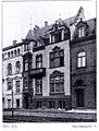
- House at Haroldstraße 6a
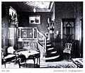
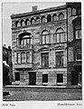
The house, built in 1900 by architects Richard Klein and Richard Dörschel , only existed until 1907. During this period, the owner and residents were the entrepreneurs Heinrich Schmidt and Henry Smith (in the company Henry Smith & Co. in Oberhausen, later on the Düsseldorfer Röhren- und Eisenwalzwerke AG was transferred ). The rooms were divided up according to the client's wishes. The cloakroom was next to the wide entrance on the basement floor. The first floor had four connected rooms grouped around the hall. Upstairs salon, were master bedroom , dining room, conservatory and porch . In 1908, a new building with number 6 was built at the same location. - House at Haroldstrasse 8 of the entrepreneur Wilhelm de Fries , built before 1905 by Heinrich Salzmann
- Office building and residential building at Haroldstrasse 10 and 10a for the Robert Zapp company , built before 1905 by Ernst Roeting

Villa Horion

Haroldstrasse 6a

Entrance to the house at Haroldstrasse 6a

Haroldstraße 6a, floor plan
Haroldstrasse 8
Haroldstrasse 8, reception room
Haroldstrasse 10a


post war period
When the Ständehaus was rebuilt for the state parliament in 1949 , this influenced the entire structural development of the area around Haroldstrasse. In a short time, many large buildings for ministries and other state authorities, the government district, were built .
- At the corner of Haroldstrasse and Horeonplatz, the high-rise Haroldstrasse No. 4 was rebuilt for the administration of the federal state of North Rhine-Westphalia in the mid-1950s. The topping-out ceremony for the building took place on October 9, 1958.
- Haroldstraße 34
The building was built according to a design by Raimund Zieseniss and completed in 1954. The stem is typical of this time. The windows have been renewed. The natural stone facade was painted completely white before 2012. - The GAP 15 building complex was completed in 2005 where Haroldstrasse meets Graf-Adolf-Platz, on the former post office site on the corner with Kasernenstrasse .

Haroldstrasse 4

Haroldstrasse 34

Low-rise building of GAP 15 from the northeast (2011)

90 meter high GAP 15 skyscraper with a view of Haroldstrasse (2014)


literature
- Werner Hensel: 75 years of surveying office of the city of Düsseldorf 1885–1960. Düsseldorf 1960.
- Hugo Weidenhaupt : A Brief History of the City of Düsseldorf. Tiltsch-Verlag, Düsseldorf 1970.
- Günther Zebisch: The urban development of the Königsallee in Düsseldorf. Dissertation, RWTH Aachen 1968/1969.
- Friedrich Tamms : Düsseldorf. Yes, this is a dark city. Econ-Verlag, Düsseldorf 1966.
- Edmund Spohr: Düsseldorf. City and fencing. L. Schwann, Düsseldorf 1978.
Web links
Individual evidence
- ↑ Heinrich Reusse. In: The German Railway . 1844, Cassel, Verlag Fischer, p. [171] 163.
- ^ In: City map Düsseldorf from 1887. Supplement to the address book of the Lord Mayor's Office in Düsseldorf . 1887, p. [14] -.
- ^ In: Düsseldorfer Kreisblatt and Daily Anzeiger . September 7, 1841, No. 242, p. [947].
- ^ A b Hermann Kleinfeld: Düsseldorf's streets and their names. Grupello, Düsseldorf 1996, ISBN 3-928234-36-6 , p. 153.
- ^ Administrative report for the year 1855. In: Etat der Stadt Düsseldorf . 1855/56, p. [7] 5. Online version
- ^ In: Administrative report for the year 1856 and budget of the city of Düsseldorf . 1856, p. [55] 56.
- ^ In: Report on the City and the Administration of Community Affairs. XII. Construction management . April 1, 1891 to March 31, 1892, p. [139] 139.
- ^ A b c Uwe Maas, Hermann Stappmann: Architectural Guide Düsseldorf. Quarters, streets, buildings. Düsseldorf 1988, p. 59.
- ^ In: Address book for the city of Düsseldorf and the mayor's offices . 1905, pp. [1311] -.
- ^ In: Report on the City and the Administration of Community Affairs. XII. Construction management . April 1, 1892 to March 31, 1893, S, [141] 141 and XIII. Public facilities . S. [153] 153.
- ^ In: Negotiations of the 49th Rhineland Provincial Landtag . 1009, p. [64] 42.
- ^ In: Address book of the city of Düsseldorf. Third part . 1934, p. [827] 12.
- ^ In: City map of Düsseldorf and Neuss . Historical Falk plan from 1949
- ^ In: Address book for the Düsseldorf administrative region . 1842/43, pp. [20 to 45] 12 to 37.
- ^ In: Address book for the Lord Mayor of Düsseldorf . 1859, p. [127] 23.
- ^ Architects and Engineers Association in Düsseldorf (ed.): Düsseldorf and its buildings. L. Schwann, Düsseldorf 1904, p. 162 f.
- ↑ Heimeshoff, p. 106 f.
- ↑ Düsseldorf address books from 1900 to 1907
- ↑ Hugo Weidenhaupt: History ... , p. 553 f.
- ^ Architects and Engineers Association in Düsseldorf (ed.): Düsseldorf and its buildings. L. Schwann, Düsseldorf 1904, p. 384 and figures 557–559.
- ↑ House record sign. 0-1-6-1928.0000
- ↑ House record sign. 0-1-6-1928.0000
- ^ Architects and Engineers Association in Düsseldorf (ed.): Düsseldorf and its buildings. L. Schwann, Düsseldorf 1904, p. 385 and figures 564–566.
- ^ Architects and Engineers Association in Düsseldorf (ed.): Düsseldorf and its buildings. L. Schwann, Düsseldorf 1904, p. 359; P. 408 and figures 646-646.
- ^ In: Administrative report of the state capital Düsseldorf. City Chronicle. Period from April 1, 1958 to March 31, 1958 . 1959, p. [11] 7.
- ^ Jörg Heimeshoff : Architecture of the fifties of the 20th century in Düsseldorf. Profane buildings without schools and bridges. (= Rheinische Kunststätten , issue 360.) L. Schwann, Düsseldorf 1990, ISBN 3-88094-671-X , p. 15.
Coordinates: 51 ° 13 ′ 7.3 ″ N , 6 ° 46 ′ 16.6 ″ E