Kalksee (Ruppiner Switzerland)
| Kalksee | ||
|---|---|---|

|
||
| Geographical location | Ostprignitz-Ruppin district | |
| Tributaries | Springs in the lake | |
| Drain | Binenbach (Schafdammgraben) | |
| Places on the shore | Binenwalde | |
| Location close to the shore | Rheinsberg | |
| Data | ||
| Coordinates | 53 ° 3 '1 " N , 12 ° 47' 41" E | |
|
|
||
| Altitude above sea level | 53.6 m above sea level NHN | |
| surface | 55 ha | |
| length | 1400 m | |
| width | 700 m | |
| volume | 4,194,375 m³ | |
| Maximum depth | 22 m | |
| Catchment area | 35.93 km² | |
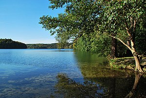
The Kalksee is an inland body of water in the Ostprignitz-Ruppin district in the northwest of Brandenburg . The Kalksee is 1.4 km long with a width of about 700 m, its surface is 55 ha (0.55 km²). The lake has no tributaries, in the southeast it is drained by the Binenbach to the Tornowsee .
The lake is part of the nature reserve Ruppiner Schweiz and the Ruppiner Seenrinne , which is formed from the Kalksee, Tornowsee , Zermützelsee , Tetzensee , Molchowsee and Rhin . The chain of lakes extends about 40 kilometers south to the upper part of the Rhinluches .
There are two bathing spots by the lake, one on the peninsula in the north (nudist) and one in the south near the drain. A hiking trail leads around the lake.
See also
Individual evidence
- ↑ a b c d e f Profile of the Kalksee ( Memento of the original from May 13, 2014 in the Internet Archive ) Info: The archive link was inserted automatically and has not yet been checked. Please check the original and archive link according to the instructions and then remove this notice. (PDF; as of March 4, 2009) from the Brandenburg State Office for the Environment, Health and Consumer Protection , accessed on November 28, 2016.
Web links
Commons : Kalksee - Collection of images, videos and audio files

