Kalle (river)
| Kalle | ||
|
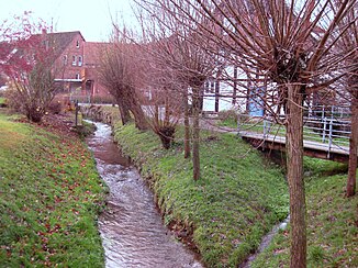
The Westerkalle in Hohenhausen |
||
| Data | ||
| Water code | EN : 4596 | |
| location | North Rhine-Westphalia , Germany | |
| River system | Weser | |
| source | Southeast of Lüdenhausen as Easter Kalle 52 ° 4 '18 " N , 9 ° 2' 15" O |
|
| Source height | 357 m above sea level NN | |
| muzzle | Northwest of Kalldorf in the Weser Coordinates: 51 ° 10 ′ 0 ″ N , 8 ° 54 ′ 19 ″ E 51 ° 10 ′ 0 ″ N , 8 ° 54 ′ 19 ″ E |
|
| Mouth height | 48 m above sea level NN | |
| Height difference | 309 m | |
| Bottom slope | 16 ‰ | |
| length | 19.6 km (incl. 15.7 km as Osterkalle) | |
| Catchment area | 82.661 km² | |
The Kalle is a 19.6 km long orographically left tributary of the Weser in North Rhine-Westphalia . It rises as Easter Kalle at the foothills of the Weserbergland . With the mouth of the 9.9 km long Westerkalle , the river is called Kalle after a stretch of 15.7 km.
location
The Kalle is located in the Lippe district on the foothills of the Weser Uplands . Near the village of Kalldorf , shortly after the source streams merge, it flows into the Weser at a height of about 48 meters above sea level east of the small town of Vlotho .
It consists of the two source streams Westerkalle , also called Kallbach in the upper reaches , and Osterkalle .
The Westerkalle rises about 2.5 kilometers south of Hohenhausen at an altitude of about 190 meters and has a length of about 12 kilometers to the Weser. The length of the somewhat longer Osterkalle is about 16 kilometers from the source to the confluence with the Weser. It rises at a height of about 240 meters southeast of the village of Lüdenhausen .
Others
The Kalle gave the large community of Kalletal, which was newly founded on January 1, 1969 from several formerly independent communities, its current name.
