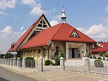
Kalna (Buczkowice)
| Kalna | ||
|---|---|---|

|
|
|
| Basic data | ||
| State : | Poland | |
| Voivodeship : | Silesia | |
| Powiat : | Bielsko-Biała | |
| Gmina : | Buczkowice | |
| Area : | 1.3 km² | |
| Geographic location : | 49 ° 42 ′ N , 19 ° 6 ′ E | |
| Residents : | 775 (2008) | |
| Postal code : | 43-376 | |
| Telephone code : | (+48) 33 | |
| License plate : | SBI | |
Kalna is a village with a Schulzenamt in the municipality of Buczkowice in the Powiat Bielski of the Silesian Voivodeship in Poland .
geography
Kalna is located in the Saybuscher Basin ( Kotlina Żywiecka ).
The village has an area of 130 ha .
Neighboring towns are Rybarzowice in the north, Łodygowice in the west, Lipowa in the south and Godziszka in the west.
history
Originally the village was called wieś Waska ( village of the Waska , Waska is a personal name) and existed before 1630. Since 1618 it belonged to the Łodygowice domain .
With the first partition of Poland in 1772 Kalna became part of the new Kingdom of Galicia and Lodomeria of the Habsburg Empire (from 1804). After the abolition of patrimonial it formed a municipality in the district and judicial district of Biała from 1850 . In 1918, after the end of the First World War and the collapse of the Austro-Hungarian monarchy, Kalna came to Poland. This was only interrupted by the occupation of Poland by the Wehrmacht in World War II .
From 1975 to 1998 Kalna was part of the Bielsko-Biała Voivodeship .
Web links
Individual evidence
- ^ UG Buczkowice: Statute Sołectwa Kalna. In: bip.ugbuczkowice.rekord.pl. Retrieved December 1, 2010 (Polish).
- ↑ Dz.U. 1975 no 17 poz. 92 (Polish) (PDF file; 783 kB)

