
Lipowa (Powiat Żywiecki)
| Lipowa | |||
|---|---|---|---|

|
|
||
| Basic data | |||
| State : | Poland | ||
| Voivodeship : | Silesia | ||
| Powiat : | Żywiec | ||
| Area : | 40.52 km² | ||
| Geographic location : | 49 ° 40 ′ N , 19 ° 6 ′ E | ||
| Residents : | see Gmina | ||
| Postal code : | 34-332 | ||
| Telephone code : | (+48) 33 | ||
| License plate : | SZY | ||
| Gmina | |||
| Gminatype: | Rural community | ||
| Gmina structure: | 6 school offices | ||
| Surface: | 58.08 km² | ||
| Residents: | 10,803 (June 30, 2019) |
||
| Population density : | 186 inhabitants / km² | ||
| Community number ( GUS ): | 2417062 | ||
| administration | |||
| Address: | Lipowa 708 34-324 Lipowa |
||
| Website : | www.ug-lipowa.com | ||

Lipowa is a village and seat of the municipality of the same name in the powiat Żywiecki of the Silesian Voivodeship in Poland .
geography
Lipowa lies in the Saybuscher Basin ( Kotlina Żywiecka ) under the Silesian Beskids (in the west).
history
The place could have been founded as early as the first half of the 14th century, with Radziechowy perhaps by the noble Radwaniten family . The parish of Lipowa (1350), Lippowa , Lipova or Lippow in the Auschwitz deanery of the Krakow diocese was mentioned in a document from 1346-1358.
Politically, the village originally belonged to the Duchy of Auschwitz , the feudal lordship of the Kingdom of Bohemia . The area of Żywiec with the village was detached from the Duchy of Auschwitz in the 1450s under unexplained circumstances. It finally belonged to Poland from 1465.
During the first partition of Poland in 1772, Lipowa became part of the new Kingdom of Galicia and Lodomeria of the Habsburg Empire (from 1804).
In 1918, after the end of the First World War and the collapse of the Austro-Hungarian monarchy, Lipowa came to Poland. This was only interrupted by the occupation of Poland by the Wehrmacht in World War II . It then belonged to the district of Saybusch in the administrative district of Katowice in the province of Silesia (since 1941 province of Upper Silesia ).
From 1975 to 1998 Lipowa belonged to the Bielsko-Biała Voivodeship .
Attractions
- Roman Catholic Church, built in 1896, with a triptych from around 1540
- Chapel (1862)

Place view

church
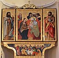
triptych

chapel


local community
The rural municipality of Lipowa includes six localities with a Schulzenamt : Leśna, Lipowa, Ostre, Sienna, Słotwina and Twardorzeczka.
Individual evidence
- ↑ population. Size and Structure by Territorial Division. As of June 30, 2019. Główny Urząd Statystyczny (GUS) (PDF files; 0.99 MiB), accessed December 24, 2019 .
- ^ Mirosław Barański: Beskid Śląski. Przewodnik . Oficyna Wydawnicza "Rewasz", Pruszków, ISBN 978-83-8918871-7 , p. 413 (Polish).
- ↑ Jan Ptaśnik (Ed.): Monumenta Poloniae Vaticana T.2 Acta Camerae Apostolicae. Vol. 2, 1344-1374 . Sums. Academiae Litterarum Cracoviensis, Cracoviae 1913, pp. 234, 244, 252, 261, 276, 284 ( online ).
- ^ Krzysztof Rafał Prokop: Księstwa oświęcimskie i zatorskie wobec Korony Polskiej w latach 1438-1513. Dzieje polityczne . PAU , Kraków 2002, ISBN 83-8885731-2 , p. 175-183 (Polish).
- ↑ Dz.U. 1975 no 17 poz. 92 (Polish, PDF; 783 kB)

Żywiec - city | Czernichów | Gilowice | Jeleśnia | Koszarawa | Łękawica | Lipowa | Łodygowice | Milówka | Radziechowy-Wieprz | Rajcza | Ślemień | Świnna | Ujsoły | Węgierska Górka