Gmina Czernichów (Powiat Żywiecki)
| Gmina Czernichów | ||
|---|---|---|

|
|
|
| Basic data | ||
| State : | Poland | |
| Voivodeship : | Silesia | |
| Powiat : | Żywiecki | |
| Geographic location : | 49 ° 45 ′ N , 19 ° 12 ′ E | |
| Residents : | see Gmina | |
| Postal code : | 34-311 | |
| Telephone code : | (+48) 33 | |
| License plate : | SZY | |
| Economy and Transport | ||
| Next international airport : | Katowice | |
| Gmina | ||
| Gminatype: | Rural community | |
| Gmina structure: | 4 localities | |
| 4 school offices | ||
| Surface: | 56.26 km² | |
| Residents: | 6774 (Jun. 30, 2019) |
|
| Population density : | 120 inhabitants / km² | |
| Community number ( GUS ): | 2417022 | |
| administration | ||
| Mayor : | Barbara Kos-Harat | |
| Address: | ul. Żywiecka 2 34-311 Czernichów |
|
| Website : | www.czernichow.com.pl | |
The Gmina Czernichów is a rural municipality in the powiat Żywiecki of the Silesian Poland Voivodeship . The village of Tresna is the seat of the municipal administration . It is named after the village of Czernichów with more than 1000 inhabitants.
The population of the municipality near the city is increasing and exceeded the 6,800 mark in 2016.
geography
The municipality is located in the Lesser Beskids , at the northern tip of the Powiat Żywiecki. It borders in the northwest on the city of Bielsko-Biała and in the south on the district town of Żywiec (Saybusch) . Other neighboring municipalities are: Kozy , Łękawica , Łodygowice , Porąbka and Wilkowice .
The most important body of water is the Soła . The river breaks through the mountains here and is dammed twice in the municipal area. The largest reservoir is the Żywiec lake (Jezioro Żywieckie) in the south of the municipality, the water reservoir has an area of 10 km². The Jezioro Międzybrodzkie is connected to the Jezioro Żar reservoir on the top of the 761 meter high Żar mountain .
The community has an area of 56.26 km² of which 22 percent are used for agriculture and 61 are covered with forest.
history
From 1975 to 1998 the municipality belonged to the Bielsko-Biała Voivodeship . In 1966 Tresna was partially flooded by Lake Żywiec .
Community partnerships
After the political change, the community entered into a partnership with Neunkirchen-Seelscheid in Germany. Further partnerships exist with Bicester , England and Csór , Székesfehérvár County in Hungary.
structure
The rural community is divided into four villages with school boards (sołectwa):
Czernichów , Tresna , Międzybrodzie Bialskie and Międzybrodzie Żywieckie .
Economy and tourism
Three hydropower plants were built on the Soła in the municipality : the reservoir of the power plant in Porąbka in 1936, the Tresna power plant in 1966 and the Porąbka-Żar pumped storage power plant in 1979. With a drop height of 440 meters and an output of 500 MW , it is one of the most powerful of its kind in Poland.
tourism
There are several marked hiking trails in the municipality, including the Little Beskydy Trail . The Żar funicular takes you to the top of the Żar and there is a ski area on its slope.
Żar ( Lotnisko dasar, EPZR) with a flying school is located on the slope of the mountain . In special weather conditions, glider flights in the lee waves of the Beskids are possible. Hang gliding is also practiced on the mountain . The nearest airfield is in Bielsko-Biała.
Attractions
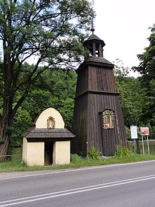
The listed sights in the main town of Czernichów include the wooden bell tower and the neighboring saint's house . The various dams and weirs on the river are of further interest.
Others
Mount Gemeindear with its weather station and glider are shown on the municipality's coat of arms , the lower half symbolizes a lake.
Web links
- Community website (Polish)
Footnotes
- ↑ population. Size and Structure by Territorial Division. As of June 30, 2019. Główny Urząd Statystyczny (GUS) (PDF files; 0.99 MiB), accessed December 24, 2019 .
- ↑ On December 31, the population was 6798 (2015), 6817 (2016) and 6805 (2017). Source: GUS : Gmina Czernichów w liczbach. (Polish; accessed April 9, 2019)
- ↑ Dz.U. 1975 no. 17 poz. 92 (PDF file, 783 kB; Polish)


