
Ślemień
| Ślemień | |||
|---|---|---|---|

|
|
||
| Basic data | |||
| State : | Poland | ||
| Voivodeship : | Silesia | ||
| Powiat : | Żywiec | ||
| Geographic location : | 49 ° 43 ' N , 19 ° 22' E | ||
| Residents : | 1977 (2008) | ||
| Postal code : | 34-323 | ||
| Telephone code : | (+48) 33 | ||
| License plate : | SZY | ||
| Gmina | |||
| Gminatype: | Rural community | ||
| Gmina structure: | 3 school offices | ||
| Surface: | 45.87 km² | ||
| Residents: | 3526 (Jun. 30, 2019) |
||
| Population density : | 77 inhabitants / km² | ||
| Community number ( GUS ): | 2417122 | ||
| administration | |||
| Address: | Ślemień 430 34-323 Ślemień |
||
| Website : | www.slemien.pl | ||

Ślemień is a village and seat of the municipality of the same name in the powiat Żywiecki of the Silesian Voivodeship in Poland .
geography
The place is located on the Łękawka River between the Little Beskids in the north and the Czeretniki ridge of the Makov Beskids in the south. The village of Gilowice is in the west, Pewel Ślemieńska , Pewel Wielka , Hucisko and Pewelka in the south, Kocoń in the east.
history
The place originated in the 15th century and was first mentioned on April 13, 1465, when the town and castle of Żywiec / Saybusch with seventeen villages of the Saybuscher Weichbild were sold by the Skrzyński brothers to the Polish king. In 1527 the village of Slemya was owned by Jakub Szaszowski. The name, originally Ślemie, is derived from the component ślemię , or possibly from the Czech slemeno - flat peak. Since 1545 Sliemye belonged to the aristocratic Komorowski family, the owners of the Saybusch country , who founded some new villages in the area such as Kocoń and Las . In 1608, Ślemień and the villages of Gilowice, Łękawica , Rychwałd , Rychwałdek , Moszczanica , Pewel Mała , Las, Kocierz, Kocoń , Kurów, Łysina and Oczków were separated from Saybusch for Aleksander Komorowski. In 1620 there was already a castle. From 1622 the Grudziński family ruled there and built a castle with towers. Katarzyna Grudzińska rebuilt the church in 1662, and from 1672 Ślemień was again the parish seat. Around 1720 the castle was replaced by a small residence. Since 1739 the manor belonged to the Wielopolski family. In the 18th century Ślemień errinerte to a town, there was a Vorwerk , a brewery, a mill, a tavern and so on.
During the first partition of Poland , Gilowice became part of the new Kingdom of Galicia and Lodomeria of the Habsburg Empire in 1772 (from 1804). From 1782 it belonged to the Myslenice district (1819 with the seat in Wadowice ). After the abolition of patrimonial , it formed a municipality in the Saybusch district after 1850 . In the 19th century Ślemień lost its importance, mainly because of the Galician Transversal Railway , which did not go through the place.
In 1918, after the end of the First World War and the collapse of the Austro-Hungarian monarchy, Ślemień came to Poland. In 1923 the village was detached from the powiat Żywiecki and connected to the powiat Makowski , but after the protests of the local population, this administrative border shift was reversed in 1931.
After the occupation of Poland by the Wehrmacht in World War II it belonged to the district Saybusch the administrative district of Katowice in the province of Silesia (since 1941 province of Upper Silesia ). In 1939 the village had 2647 inhabitants. In the action Saybusch 145 families and 615 Poles were forcibly resettled in Ślemień on 29 October 1940 to make it volksdeutschen with 38/39 families or 178-183 settlers (164 Roman Catholics, 14 Protestants) from eastern Galicia and Bukovina to settle. The reduction of the population to 1850, the complete Germanization and the renaming to Friedrichswald were planned for the village, but not introduced before the end of the world war.
From 1975 to 1998, Ślemień was part of the Bielsko-Biała Voivodeship .
Attractions
- Roman Catholic Church, built 1842–53
- Jasna Górka sanctuary and chapel (1858)
- open air museum
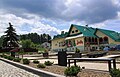
Marketplace

church

Jasna Górka sanctuary

open air museum

.JPG)


local community
The rural municipality of Ślemień includes three localities with a Schulzenamt : Kocoń, Las and Ślemień.
Individual evidence
- ↑ population. Size and Structure by Territorial Division. As of June 30, 2019. Główny Urząd Statystyczny (GUS) (PDF files; 0.99 MiB), accessed December 24, 2019 .
- ^ Przemysław Stanko: Monografia Gminy Wilkowice . Wydawnictwo Prasa Beskidzka, Wilkowice 2014, ISBN 978-83-940833-0-4 , p. 74-75 (Polish).
- ↑ Zywyecz, Lichtenwald, Sliemye. Krótka etymologia nazwy
- ↑ Władysław Lubas: nazwy miejscowe Południowej części dawnego województwa Krakowskiego . Polska Akademia Nauk . Instytut Języka Polskiego, Wrocław 1968, p. 150 (Polish, online ).
- ↑ Radosław TRUS: Beskid Mały. Przewodnik . Oficyna Wydawnicza "Rewasz", Pruszków 2008, ISBN 978-83-8918877-9 , p. 318-322 (Polish).
- ↑ Mirosław Sikora: Niszczyć, by tworzyć. Germanizacja Żywiecczyznyprzez narodowosocjalistyczne Niemcy 1939–1944 / 45 [Destroying to Create. The Germanization of the Zywiec District by National Socialist Germany 1939–1944 / 45] . Oddział Instytutu Pamięci Narodowej - Komisji Ścigania Zbrodni przeciwko Narodowi Polskiemu w Katowicach, Tarnowskie Góry 2010, ISBN 978-83-7629-229-8 , p. 223, 254, 358, 377, 513, 615, 619 (Polish, online ).
- ↑ Dz.U. 1975 no 17 poz. 92 (Polish) (PDF file; 783 kB)
Web links
- Ślemień . In: Filip Sulimierski, Władysław Walewski (eds.): Słownik geograficzny Królestwa Polskiego i innych krajów słowiańskich . tape 10 : Rukszenice – Sochaczew . Walewskiego, Warsaw 1889, p. 757 (Polish, edu.pl ).

Żywiec - city | Czernichów | Gilowice | Jeleśnia | Koszarawa | Łękawica | Lipowa | Łodygowice | Milówka | Radziechowy-Wieprz | Rajcza | Ślemień | Świnna | Ujsoły | Węgierska Górka