
Kaltehofe
| Kaltehofe | ||
|---|---|---|
 |
||
| Waters | Lower Elbe | |
| Geographical location | 53 ° 31 '28 " N , 10 ° 3' 19" E | |
|
||
| length | 1.8 km | |
| width | 520 m | |
| surface | 60 ha | |
 |
||

Kaltehofe (also Kalte Hofe ) is an Elbe island in the Hamburg district of Hamburg-Rothenburgsort .
geography

The island of Kaltehofe is bordered in the north and east by the Billwerder Bay, which continues in the south in the Alte Dove Elbe (formerly connected with and part of the Dove Elbe ). The island of Billwerder Ausschlag is 125 meters to the north , connected to the Billwerder Bay barrage (bridge connection). In the south-west it is separated from the Elbe island Peute, which belongs to Hamburg-Veddel , by the 230 meter wide northern Elbe .
The island is 1.8 km long from northwest to southeast and 520 meters wide in the central area, tapering to a point at the ends. The area covers around 60 hectares .
In the south, the Kaltehofe is connected to the mainland (Elbe water filter plant in Moorfleet , Billwerder Insel ) via the 400 meter long and 110 meter wide main Elbe dike .
The Elbe water filtration plant of the Hamburg waterworks , built in 1893, is located on the island ; it has been out of service since February 1990. The water basins, which are no longer used, serve birds such as the little grebe as resting and breeding grounds. Use and development of the Elbe island has so far failed due to unfavorable location factors and the different interests of those involved.
There is a small boat yard in the north.
On September 18, 2011 , Hamburg Wasser opened the Wasserkunst Kaltehofe on the site of the former Kaltehofe waterworks . It is considered a mixture of industrial monument, museum and nature trail.
history

Records from the 17th century show that the area was used as pasture or for harvesting hay and thatch, but also for catching birds and fishing. Around the year 1700 a mill and a brewery settled there. By 1766 four more breweries and a distillery were added. Their products found good sales in the nearby harbor. Through the Gottorp Treaty of 1768, the formerly Danish Kalthofe was incorporated into the city of Hamburg and incorporated into the parish of Billwerder-Moorfleet. The area was diked, but was not suitable for permanent settlement as it was still regularly flooded. In 1811 there were only 81 residents who lived in a few small cottages and two country houses. In 1847 there were 87 residents. The increasing trade in goods through the city of Hamburg made it necessary to expand the port of Hamburg . The general plan drawn up in the 1870s to 1880s provided for regulation of the Elbe in the Kaltehofe area.
The island was created when a breakthrough was made between 1875 and 1879, thereby straightening the course of the Norderelbe and separating the area of the Kaltehofe from the Peute . The original course of the Norderelbe led in the east of the Kaltehofe through Billwerder Bay and today's Holzhafen, which are now separated from the Elbe by a barrage .
Previously, after the devastating fire of 1842 , in which all existing water art on the Alster was destroyed, a new water art near the Billwerder Bay above the city area was built. In the years 1844 to 1848 the most modern urban water supply company in Europe was created. The water was pumped into three sedimentation tanks with steam pumps and then, after a rest period of 24 hours, passed into the city via a riser tower, which also generated sufficient pressure in the event of a fire. In 1852 this facility was expanded to include a fourth basin. However, there was no filtration at all, so that the pipelines were blocked, for example by eels or other fish, in the area of the domestic water taps. Although the civil engineer in charge, William Lindley, had already submitted plans for the installation of a sand water filter in 1853, the implementation failed due to a lack of funds. It was not until 1888 that a decision was made to install a modern filtration system in order to improve the water quality. The last major cholera epidemic of 1892 broke out during the construction phase, which began in 1890 and was headed by the hydraulic engineer Franz Andreas Meyer . The expansion of the facility, which was initially rather slow, now became an urgent matter, since Robert Koch had already proven a connection between contaminated drinking water and the disease of cholera in 1884 . This was also confirmed in the Hamburg area, where the city of Altona , which had been supplied with filtered drinking water since 1859, was largely spared the epidemic.
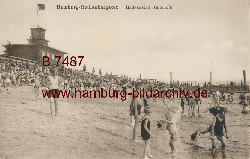
The increasing water pollution in the area of the scoop for the Elbe water caused criticism of the water quality to get louder around 1900. In 1905 a groundwater works was put into operation in Billbrook. Despite the polluted river water , the last Elbbadeanstalt was opened in 1930 on Kaltehofe, opposite the site of the North German Affinerie . During World War II, the island was hit by 88 bombs, severely destroying many of the 22 filtration basins. By 1954 only 8 of them could be put back into operation. After the war, employees and their families were sometimes housed in the company buildings. The bathing establishment was operated until 1958 and was finally demolished after the great storm surge in 1962 , which also contaminated the basins of the filtration system. The filter system on Kaltehofe was in operation until 1990; after the closure, the company buildings fell into disrepair. There were different plans for re-use, including an expansion with 1,500 residential units, 104,000 square meters of office space and around 11,000 square meters of retail space. However, this was rejected by both the monument office and the urban development authority. Instead, the entire island was placed under protection and the Villa Kaltehofe and the filter systems with their valve houses and basins were declared a monument.
literature
- Architects and Engineers Association of Hamburg (ed.): Hamburg and its buildings taking into account the neighboring cities of Altona and Wandsbek 1914. Part 2 self-published. des Verein, Hamburg 1914, OCLC 176742944 diglib.tugraz.at
- Otto Schertel: water supply. P. 365 ff.
- Elbbadeanstalt. - Top view / site plan p. 406, - Cross section p. 407.
- Eva Decker, Jörg Schilling: Wasserkunst Elbinsel Kaltehofe (= Hamburg construction books. 15). Hamburg 2016, ISBN 978-3-944405-22-3 .
Web links
- Wasserkunst Kaltehofe
- A cultural monument - without monument protection and with signs of deterioration (PDF, p. 3/4) on karo4tel.de
- April 2, 2016 Kaltehofe: Industrial monument & nature preserve on rfehr.eu
Individual evidence
- ↑ Hanne Hollstegge: Sustainable uses for Kaltehofe ?! Qualities and opportunities of the Rothenburgsorter Wasserkunstinsel in Hamburg (PDF; 2.7 MB) Concept. Diploma thesis, Hamburg University of Technology, October 20, 2004.
- ↑ www.luetje-yachts.com
- ↑ A new natural and cultural experience on the Elbe island Kaltehofe. ( Memento of the original from April 26, 2016 in the Internet Archive ) Info: The archive link was automatically inserted and not yet checked. Please check the original and archive link according to the instructions and then remove this notice. on hamburgwasser.de, press release Hamburg Wasser from September 18, 2011.
- ^ A b Eva Decker, Jörg Schilling: Wasserkunst Elbinsel Kaltehofe (= Hamburg construction books. 15). Hamburg 2016, ISBN 978-3-944405-22-3 , pp. 5-11.
- ↑ Kathrin Maas: Hamburg: Epidemic from the Elbe. (No longer available online.) In: Der Spiegel. May 28, 2013, archived from the original on April 18, 2016 ; Retrieved April 18, 2016 . Info: The archive link was inserted automatically and has not yet been checked. Please check the original and archive link according to the instructions and then remove this notice.
- ↑ Elbbadeanstalt Kaltehofe 1931 on hamburg-bildarchiv.de
- ^ Eva Decker, Jörg Schilling: Wasserkunst Elbinsel Kaltehofe. Pp. 23-28.
- ↑ Expert opinion: Elbwasserwerk Kaltehofe with the pumping station on Billwerder Island and the filter plant on Kaltehofe Island (PDF) on karo4tel.de