Kamanje
| Kamanje | ||
|
||
|
|
||
| Basic data | ||
|---|---|---|
| State : |
|
|
| County : |
|
|
| Municipality : | Kamanje | |
| Area : | 18 km² | |
| Residents : | 891 (2011) | |
| Population density : | 50 inhabitants per km² | |
| Telephone code : | (+385) 047 | |
| Postal code : | 47282 | |
| License plate : | KA | |
| Structure and administration (status: 2013, cf. ) |
||
| Community type : | local community | |
| Mayor : | Damir Mateljan ( SDP ) | |
| Website : | ||
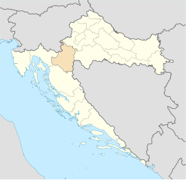
Kamanje is a municipality in the Karlovac County in central Croatia .
location
The place is on the route Karlovac via Ozalj towards Metlika not far from the Slovenian border, which was built during the construction of the railway line before the First World War . The community has 891 inhabitants (as of 2011). This emerged from the Croatian reorganization of the municipalities in 2003.
history
Kamanje itself was founded in the 15th century. Over time, more and more farmers from the surrounding valleys settled there and so a large settlement was created. The localities of Brlog , Mali Vrh , Preseka , Orljakovo and Restovo belong to the municipality today .
The parish church of Sveta Marija is dedicated to the Blessed Virgin Mary and was built in 1889 on a hill in the center of the village in neo-Gothic style. It is a single-nave building with a narrow, polygonal chancel and a bell tower over the main facade. The beautiful frescoes inside were added in 1895. For more than two centuries there has been an annual procession in September on the name day of the Blessed Virgin Mary, to which pilgrims from Croatia and neighboring Slovenia come.
particularities
A special feature is the Vrlovka Cave , a geomorphological natural monument on the outskirts of Kamanje . This is well known among the researchers because it was used as a refuge by the indigenous people over 1000 years ago. In times of heavy rain you can admire the running water as small brooks. The total length is over 400 m and almost completely (330 m) accessible to tourists.
The Vrlovka - Vodenice hiking trail from the cave to the Vodenice mountain at 537 m. The hiking trail takes about 2½ hours.

