
Ogulin
| Ogulin | |||
|
|||
|
|||
| Basic data | |||
|---|---|---|---|
| State : |
|
||
| County : |
|
||
| Height : | 323 m. i. J. | ||
| Area : | 542.32 km² | ||
| Residents : | 13,915 (2011) | ||
| Population density : | 26 inhabitants per km² | ||
| Telephone code : | (+385) 047 | ||
| Postal code : | 47 300 | ||
| License plate : | 1st floor | ||
| Structure and administration (status: 2013, cf. ) |
|||
| Community type : | city | ||
| Mayor : | Jure Turković ( HDZ ) | ||
| Postal address : | Bernardina Frankopana Street 9 47300 Ogulin |
||
| Website : | |||


Ogulin is a town in central Croatia and is 323 meters above sea level . Administratively, the city belongs to the Karlovac County . According to the 2011 census, the city has 13,915 inhabitants, 80.2% of whom are Croatians and 17.7% are Serbs . The urban area of Ogulin has 8,216 inhabitants.
Ogulin is located in the heart of Croatia, halfway between Zagreb and Rijeka and within the tourist area between the Plitvice Lakes National Park in the southeast, the forested Gorski kotar in the west and the northern Adriatic , which is a little further west.
geography
The area of the municipality with its 24 settlements is 542.32 km².
Ogulin is located at the foot of the Klek mountain . The canyon of the river Dobra extends up into the city where the flow through a Schwinde called Đulin ponor (dt. Julia ponor ) in the m with 16396 longest cave Croatia Medvedica continues to flow.
history
Ogulin was built around the fortress, which was built by the Frankopan family towards the end of the 15th century. From the 16th century, the city was further fortified as part of the military border. A more intensive development can be observed in the 19th century, when Ogulin was chosen to be the seat of the Modruš County .
Sons and daughters
- Ivana Brlić-Mažuranić (1874–1938), Croatian writer.
- Ante Pavić (* 1989), Croatian tennis player
- Ema Pukšec (1834–1889), opera singer, also known by the stage name Ilma De Murska
- Petar Stipetić (* 1937), Croatian general
Monuments and landmarks
- Dobra canyon with Schwinde Dulin ponor
- Fort of the Frankopans
- Statue of Tomislav I , the first Croatian king
Web links
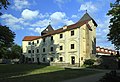
Ogulin Castle, courtyard

The legendary local mountain of Ogulin Klek

Shrinkage Ðulin ponor

Climate diagram of Ogulin


