
Kamenari
|
Kamenari Каменари |
|||||
|
|||||
| Basic data | |||||
|---|---|---|---|---|---|
| State : |
|
||||
| Municipality : | Herceg Novi | ||||
| Coordinates : | 42 ° 28 ' N , 18 ° 40' E | ||||
| Residents : | 747 (2011) | ||||
| Telephone code : | (+382) 031 | ||||
| Postal code : | 85340 | ||||
| License plate : | HN | ||||


Kamenari is a local community ( mjesna zajednica ) in the Herceg Novi municipality in Montenegro . In 2011 there were 747 inhabitants in the three villages of Jošice (411), Djurići (303) and Bijelske Kruševice (33).
Kamenari is located about 11 km east of Herceg Novi on the bank of Verige Strait , a strait that separates the inner part of the Bay of Kotor from the outer. The place name is derived from the reddish limestone ( came = 'stone'), which has been broken here for centuries and which was not only used in the construction of palaces and churches as well as in the paving of streets and squares in the vicinity, but also in Venice and Odessa .
Kamenari is known for the ferry connection to Lepetane on the opposite side of the Verige Street, which has existed since 1898. In the summer season, four car ferries now operate all day, in winter between midnight and 6 a.m. only about every hour. Depending on the current and wind conditions, you will need between 5 and 10 minutes to cross the strait. For cars, the journey time to Budva or Podgorica is shortened by approx. 45 minutes using the ferry, as the entire inner bay of Kotor has to be bypassed on the embankment.
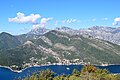
View from Sv. Vid on the Vrmac peninsula on Kamenari

Ferry dock in Kamenari

Teodo ferry

Sveta Nedjelja Church, built in 1704


Individual evidence
- ↑ Herceg-Novi municipality: Generalni urbanisticki plan Herceg-Novi . Herceg Novi 2007, p. 12 (Montenegrin)
- ↑ Statistical Office of Montenegro - MONSTAT: Census of Population, Households and Dwellings in Montenegro (PDF; 771 kB). Podgorica 2011. ISBN 978-86-85581-36-6 (Montenegrin / English)
- ↑ Kamenari - Montenegro at www.montenegro.com, accessed on October 17, 2017 (English)
- ↑ Damir Magaš: Natural-Geographic Characteristics of the Boka Kotorska Area as the Basis of Development (PDF; 545 kB). In: Geoadria . Volume 7, No. 1, 2002, pp. 51-81 (English)
- ↑ History of the Kamenari – Lepetane ferry (English), accessed on October 19, 2017
- ↑ Timetable of the ferry Kamenari – Lepetane (English), accessed on October 19, 2017
- ^ Achim Wigand: Montenegro . 4th completely revised and updated edition 2017, Michael Müller Verlag, Erlangen 2006–2017, p. 99. ISBN 978-3-95654-213-8