Kangchungtse
| Kangchungtse | ||
|---|---|---|
|
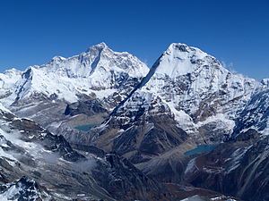
left Makalu, right Chamlang ; the rise to the left of the Makalu is the Kangchungtse |
||
| height | 7678 m | |
| location | District Sankhuwasabha ( Nepal ), Tibet ( China ) |
|
| Mountains | Mahalangur Himal ( Himalaya ) | |
| Dominance | 3.02 km → Makalu La | |
| Notch height | 251 m ↓ ( 7427 m ) | |
| Coordinates | 27 ° 54 '54 " N , 87 ° 4' 43" E | |
|
|
||
| First ascent | October 22, 1954 by Jean Franco , Lionel Terray , Sardar Gyaltsen Norbu and Pa Norbu | |
The Kangchungtse (also Makalu II ) is a glaciated peak in the Himalayas on the border between Nepal and the autonomous region of Tibet .
The 7,678 m high Kangchungtse forms a north-western secondary peak of the eight-thousander Makalu ( 8,485 m ). It is located at a distance of 3.02 km from the main summit, on the ridge that connects the Makalu with the Mount Everest massif. The 7427 m high Makalu La saddle lies between Kangchungtse and Makalu . 3.37 km northeast, on the other side of the Chomolonzo glacier , rises the slightly higher Chomo Lönzo with an altitude of 7804 m .
Ascent history
The first ascent of the Kangchungtse was achieved in 1954 by a French mountaineering group as part of an exploration expedition of the Makalu. On October 22, 1954, Jean Franco , Lionel Terray , Sardar Gyaltsen Norbu and Pa Norbu reached the summit from Makalu La via the south ridge.
Web links
- Kangchungtse on Peakbagger.com (English)

