
Kangertittivaq
Coordinates: 70 ° 30 ′ N , 25 ° 0 ′ W


The Kangertittivaq ( Tunumiisut for large fjord , Kitaamiusut Kangerlussuaq , Danish Scoresby Sund ) is a fjord system in the Greenland Sea on the east coast of Greenland . It has a tree-like structure, the 110 km long main basin of which branches off into several fjords and thus has a total area of 38,000 km² (for comparison: Denmark has an area of around 43,000 km²). The longest fjord extends over 340–350 km. The depth is 400–600 m in the main basin, in the fjords it falls to 1450 m. It is the largest and longest fjord system in the world.
The fjord complex was named in honor of the English explorer William Scoresby , who relatively accurately mapped the east coast of Greenland between 69 ° and 75 ° north in 1822. The exploration and detailed mapping of the inner fjord was carried out by Carl Ryder in 1891/92 . There are numerous islands there. The largest of them, Milne Land , covers an area of 3,913 km² and is located in the middle of the inlet. On the north side of the exit is Ittoqqortoormiit , the only permanently populated city in the area with 472 inhabitants (as of 2011).
geography

The exit between Kangikajik (Cape Brewster) and Uunarteq (Cape Tobin) is 29 km wide. Its southern part is a steep, 1000-2000 m large basalt wall , the northern side is lower and more rounded. The estuary continues west for 110 km, then turns slightly north, expanding and forming a basin called Hall Bredning. From there, the inlet splits into several branches, including the Northwest Fjord, Øfjord (which in turn is divided into Rypefjord and Harefjord), Røde Fjord, Gasefjord and Fønfjord. Milne Land lies between the Øfjord and the Fønfjord. The land surrounding the fjord is mountainous and has towering cliffs right on the fjord. In some places there are also glaciers .
climate
The climate is very arctic, as shown by a long cold winter and violent storms. The temperatures from January to March fluctuate between −22.5 and −8.4 ° C, the average from 1971–1981 between −15 and −18 ° C. In the short summer, the temperatures are essentially less than +5 ° C; in 1971–1981 they fluctuated between +0.5 and +3 ° C. The first snowfall usually sets in in September and continues into June, and the fjord freezes over towards the end of October. Between late November and mid-January the sun does not rise above the horizon. There is little rainfall, around 30 mm per month. Twice a day there are tides with a tidal range of 1.3 meters.
|
Average monthly temperatures and precipitation for the Kangertittivaq
Source:
|
||||||||||||||||||||||||||||||||||||||||||||||||||||||||||||||||||||||||||||||||||||||
fauna

The fauna of the area is exceptionally rich for Greenland. This is due to some special factors, such as the availability of free water in the exit in the form of polynjas , which do not freeze even in winter, as well as protection from winds due to the high relief, and relatively fertile land. The animals on land include musk ox , arctic fox , ermine , mountain hares and lemmings . The reindeer and arctic wolf lived here once but disappeared around the 20th century.
Among the birds are found barnacle geese , pink-footed geese , snow geese , whooper swans , King Eider , eiders , long-tailed ducks , thick-billed murres , black guillemots , auks , puffins , fulmars , herring gulls , glaucous gulls , gulls , kittiwakes , arctic terns , red-throated divers , common loon , red-breasted merganser , ptarmigan , ravens , snow -Eulen , Greenlandic gyrfalcon etc. most of them are expatriate species and form large colonies that can consist of millions of individuals (eg. auks).
The fish include the arctic char , the black halibut , the polar cod , the cuttlefish , the striped sea wolf , sea scorpions and the greenland shark . The majority of the mammals in the water are taken up by seals ( ringed , bearded , harp seals , collapsible caps and harbor seals ), which feed on fish (mostly polar cod) in winter and crustaceans in summer . Larger specimens are the Atlantic walrus , the narwhal and sometimes the beluga .


photos

Kangertittivaq
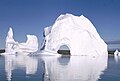
Icebergs in July 1970
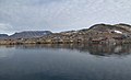
View of Ittoqqortoormiit in summer


Individual evidence
- ↑ The place Ittoqqortoormiit is called "Scoresbysund", while the adjacent fjord is called "Scoresby Sund".
- ^ Scoresby Sund , Encyclopedia Britannica online
- ↑ a b c Article Scoresby-Sund in the Great Soviet Encyclopedia (BSE) , 3rd edition 1969–1978 (Russian)
- ↑ a b Sandell, p. 7
- ↑ Piotr MIGON: geomorphological Landscapes of the World. Springer, 2010, ISBN 90-481-3054-9 , p. 227.
- ↑ Greenland in Figures 2011. Statistics Greenland, accessed on August 2, 2011 (English, May 2011).
- ↑ a b Sandell, pp. 8–9
- ↑ a b Sandell, p. 11
- ^ Sandell, p. 18
- ↑ Sandell, pp. 19-20
- ^ Sandell, p. 21
- ↑ a b Sandell, pp. 12-14
literature
- Hanne Tuborg Sandell, Birger Sandell: Archeology and Environment in the Scoresby Sund Fjord: Ethno-Archaeological Investigations of the Last Thule Culture of Northeast Greeland . Museum Tusculanum Press, 1991, ISBN 87-635-1208-4 (English, limited preview in Google book search).