Kasai (river)
|
Kasai Kwa, Kassabi, Ibari, Nkutu, Kassai, Cassai |
||
|
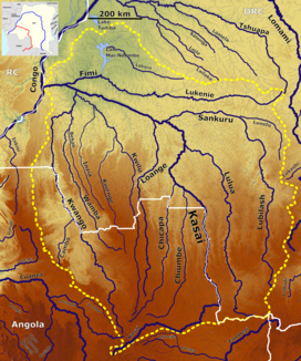
The catchment area of the Kasai with its tributaries |
||
| Data | ||
| location |
|
|
| River system | Congo | |
| Drain over | Congo → Atlantic | |
| source |
Bié highlands 10 ° 57 ′ 37 ″ S , 19 ° 18 ′ 56 ″ E |
|
| muzzle |
Congo Coordinates: 3 ° 10 ′ 35 " S , 16 ° 11 ′ 48" E 3 ° 10 ′ 35 " S , 16 ° 11 ′ 48" E
|
|
| length | 2153 km | |
| Catchment area | 881,890 km² | |
| Discharge at the Kutu-Moke gauge (1147200) A Eo : 737,640 km² Location: 80 km above the mouth |
MNQ 1932-1959 MQ 1932-1959 Mq 1932-1959 MHQ 1932-1959 |
4400 m³ / s 8108 m³ / s 11 l / (s km²) 11,600 m³ / s |
| Left tributaries | Chicapa , Loange , Kwango | |
| Right tributaries | Lulua , Sankuru , Fimi | |
| Big cities | Bandundu | |
| Medium-sized cities | Tshikapa | |
| Waterfalls: Pogge-Fall , Wissmann-Fall , Mayi-Munene-Fall | ||
|
The Kasai near Tshikapa |
||
|
The Mayi Munene case |
||
The 2,153 km long Kasai (also known as Kassabi , Ibari , Nkutu , Kassai , Cassai ( Portuguese ) and in the lower reaches of the Kwa ) is a left tributary of the Congo in Central Africa . With a water flow of over 8000 m³ / s, it is by far the largest tributary of the Congo.
course
The river has its source in the eastern part of the Angolan highlands of Bié and flows from there in an easterly direction to the border of the Democratic Republic of the Congo , where it bends at a 90 ° angle to the north and is a border river for about 400 km. Here the river bed is rich in islands and is sometimes up to 10 km wide. Flowing further north, the Kasai reaches the Congo Basin and bends in it to the northwest. Further flowing in this direction, the Kwilu flows north of Bandundu . For the last 50 km, from the mouth of the Fimi (Mfimi) over which the Mai-Ndombe-See drains, it is called Kwa . The Kwa flows into the Congo about 170 km (as the crow flies ) northeast of Kinshasa .
In its course there are several larger waterfalls, the Pogge Fall (at 6 ° 40 'south latitude) and the Wissmann Fall (at 5 ° 50' south latitude). Further up in its course are the Mayi-Munene cases . From the left come the main tributaries of the Kasai: Chicapa , Loange and the Kwango . From the right the Lulua , Sankuru and the Lukenie (Msini, Ikatta) flow over the Fimi.
Drain
After the start of the rainy season in October, the river rises by about 4 m. When the water level is high, it discharges around 12,000 m³ of water per second at its mouth. The length of the navigability is around 3,500 km including the tributaries. The main river itself is navigable up to the Wissmann Fall.
The discharge would be measured from 1932 to 1959 at the Kutu-Moke station about 80 km above the mouth in m³ / s (read from the diagram).


