
Kaserbach
| Kaserbach | ||
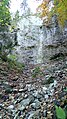
 Kaserbach approx. 1040 m altitude |
||
| Data | ||
| location |
Northern Limestone Alps
|
|
| River system | Danube | |
| Drain over | Auerbach → Inn → Danube → Black Sea | |
| source | Trenches below Brünnstein and Brünnsteinschanze 47 ° 39 ′ 10 ″ N , 12 ° 5 ′ 17 ″ E |
|
| Source height | approx. 1253 m | |
| muzzle | in the Auerbach coordinates: 47 ° 40 ′ 0 ″ N , 12 ° 6 ′ 1 ″ E 47 ° 40 ′ 0 ″ N , 12 ° 6 ′ 1 ″ E |
|
| Mouth height | 670 m | |
| Height difference | approx. 583 m | |
| Bottom slope | approx. 28% | |
| length | 2.1 km | |
The Kaserbach is a year-round flowing water in the Mangfall Mountains .
It arises from several ditches on the northern slopes of Brünnstein and Brünnsteinschanze , flows largely northwards, before flowing into the Auerbach from the right.
gallery
Inflow to the Kaserbach on a rock ledge at an altitude of approx. 1100 m.

Web links