Kaukapakapa
| Kaukapakapa | ||
| Geographical location | ||
|
|
||
| Coordinates | 36 ° 37 ′ S , 174 ° 29 ′ E | |
| Region ISO | NZ-AUK | |
| Country |
|
|
| region | Auckland | |
| District | Auckland Council | |
| Ward | Rodney Ward | |
| Local foundation | 1860 | |
| Residents | 444 (2013) | |
| height | 13 m | |
| Post Code | 0873 | |
| Telephone code | +64 (0) 9 | |
| Photography of the place | ||
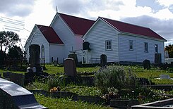
 Church in Kaukapakapa |
||
| Remarks | ||
| Kaukapakapa was part of the Rodney District until October 2010 | ||
Kaukapakapa is a village in the Auckland Council urban areaon the North Island of New Zealand . Until October 2010, the village belonged to the Rodney District , which wasassigned tothe newly formed Auckland Council from November 1, 2010.
Origin of name
In the Māori language, Kaukapakapa means "swimming with a lot of splashing", where "kau" stands for swimming and "kapakapa" for flapping the wings. The place got this name because the wild ducks in the river flap their wings on the water when they are scared.
geography
The village is located around 18 km west of Orewa and around 35 km northwest of downtown Auckland on a small plain that opens up around 5 km east of the Kawa Parua Inlet , the southern part of Kaipara Harbor . Helensville , the next largest town, is 7.5 km to the southwest. The Kaukapakapa River flows south of the community in a westerly direction and flows into the Kawa Parua Inlet .
history
The Kaukapakapa District was established in 1860 when the government bought land from the local Māori and sold some to a handful of settlers. In the 1860s and early 1870s, more settlers came from Scotland and England .
In 1872 a Methodist church was built in the village. From 1963 there was a monthly boat connection between Kaukapakapa and the northern Kaipara . As early as the early 1880s there were roads to Riverhead , Tauhoa and Helensville . However, these were of poor quality, so the river remained the main route. In 1920 the road surface was still largely gravel.
The development of the region around Kaukapakapa is based on the timber industry. The wood from the felled kauri trees was driven down the Kaukapakapa River into Kaipara Harbor by rafts , where it was loaded onto ocean-going vessels for export. The search for fossil kauri resin , the so-called " gum-digging ", began in 1873/74 and continued until at least 1914. Another industry was the processing of New Zealand flax in the 1880s . From 1864 to the 1880s there was a shipyard for shipbuilding.
The North Auckland Railway reached Kaukapakapa in 1889. A butter-making dairy was built near the station to support the developing dairy industry.
population
In 1881 the Kaukapakapa area had 311 residents. For the 2013 census, statisticians counted 444 inhabitants.
Infrastructure
Road traffic
New Zealand State Highway 16 runs through the village and connects it with Helensville in the southwest and Wellsford in the north.
Rail transport
The North Auckland Line railway also runs through the village, but does not offer any connection.
Education
The village has two pre-school facilities, the Kaukapakapa Pre-School near the elementary school and a Playcentre founded in 1976 on Macky Road .
With the Kaukapakapa School , the village has a primary school for the 1st to 8th grade and in 2015 had 256 students. The school celebrated its 125th anniversary in 1998. In addition, the elementary school is one in Waitoki to kaukapakapa .
media
Kaukapakapa had a local newspaper, the " Kaukapakapa Kourier " , which was distributed to the residents by post . This was also available in PDF format.
Personalities
- Tony Woodcock (born 1981),national rugby player
- Clint Brown , former TV3 news anchor
literature
- Helga Neubauer: Kaukapakapa . In: The New Zealand Book . 1st edition. NZ Visitor Publications , Nelson 2003, ISBN 1-877339-00-8 , pp. 188 .
Individual evidence
- ↑ a b 2013 Census QuickStats about a place: Rodney Local Board Area -> StatsMap. Statistics New Zealand , accessed on June 22, 2017 (English, StatsMap: Meshblock analysis from the interactive map).
- ^ AW Reed : The Reed Dictionary of Māori Place Names . Reed Books , Auckland 1996 (English).
- ^ Neubauer: Kaukapakapa . In: The New Zealand Book . 2003, p. 188 .
- ↑ a b c Topo250 maps . Land Information New Zealand , accessed June 22, 2017 .
- ^ Kaukapakapa History . Helensville Museum , accessed June 22, 2017 .
- ^ A b c d Wayne Ryburn : Tall Spars, Steamers & Gum . Kaipara Publications , Auckland 1999, ISBN 0-473-06176-7 , pp. 25 (English).
- ↑ Kaukapakapa Playcenter . NZ Playcentre Federation , accessed June 22, 2017 .
- ↑ Te Kete Ipurangi - Kaukapakapa School . Ministry of Education . Retrieved February 16, 2015.

