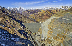
Kiğı Dam
| Kiğı Kığı Barajı ve Hidroelektrik Santrali |
|||||||||
|---|---|---|---|---|---|---|---|---|---|
|
|||||||||
|
|
|||||||||
| Coordinates | 39 ° 22 ′ 6 ″ N , 40 ° 21 ′ 7 ″ E | ||||||||
| Data on the structure | |||||||||
| Lock type: | Rock embankment dam with a clay core | ||||||||
| Construction time: | 1998-2016 | ||||||||
| Height of the barrier structure : | 146 m | ||||||||
| Height above valley floor: | 150 m | ||||||||
| Height above foundation level : | 168 or 170 m | ||||||||
| Building volume: | 17.39 or 23 million m³ | ||||||||
| Crown length: | 585 m | ||||||||
| Power plant output: | 180 MW | ||||||||
| Operator: | Office for Water Management (DSI) | ||||||||
| Data on the reservoir | |||||||||
| Water surface | 8.35 km² | ||||||||
| Storage space | 508 or 1200 million m³ | ||||||||
| Design flood : | 4th 500 m³ / s | ||||||||
The Kiğı Dam ( Turkish: Kığı Barajı ) is a stone embankment dam with a clay core at Peri Çayı , a tributary of the Murat , in the district of Kiğı in the province of Bingöl in eastern Turkey, about seven kilometers north of the city of Kiğı and 55 kilometers north of the provincial capital Bingöl . The dam is used to generate energy. The three Francis turbines of the hydropower plant will have 3 × 60 = 180 MW nominal output. Other figures speak of 140 MW. The expected standard energy capacity is 650 GWh per year. The client is the Turkish Water Management Authority DSI. The Özlüce Dam is located downstream .
See also
- List of the largest dams on earth
- List of the largest reservoirs on earth
- List of the largest hydroelectric plants in the world
- List of dams in the world
Individual evidence
- ↑ a b c d Bingol Regional Office , State Hydraulic Works, accessed January 1, 2013 (Turkish)
- ↑ a b Kigi Dam and HEPP ( Memento of the original from May 8, 2012 in the Internet Archive ) Info: The archive link has been inserted automatically and has not yet been checked. Please check the original and archive link according to the instructions and then remove this notice. , Ozaltin, accessed January 1, 2013
- ↑ https://www.haberler.com/kigi-baraji-nda-su-tutulmaya-baslandi-8042274-haberi/

