Kilsyth
|
Kilsyth Scottish Gaelic Cill Saidhe |
||
|---|---|---|
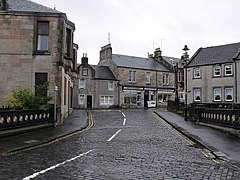
| Buildings in the city center | ||
| Coordinates | 55 ° 59 ′ N , 4 ° 3 ′ W | |
|
|
||
| Residents | 9885 2011 census | |
| administration | ||
| Post town | GLASGOW | |
| ZIP code section | G65 | |
| prefix | 01236 | |
| Part of the country | Scotland | |
| Council area | North Lanarkshire | |
| British Parliament | Cumbernauld, Kilsyth and Kirkintilloch East | |
| Scottish Parliament | Cumbernauld and Kilsyth | |
Kilsyth ( Gaelic : Cill Saidhe ) is a town in the Scottish Council Area of North Lanarkshire .
geography
Kilsyth is the northernmost town in North Lanarkshire. It is located in the Central Belt about 18 km northeast of Glasgow , southwest of Stirling and west of Falkirk . Kilsyth is the capital of the Parish of the same name , which borders with three surrounding council areas, Stirling , Falkirk and East Dunbartonshire . In the north, the urban area is bounded by the Kilsyth Hills and in the south by the Kelvin River . The northeastern Garrel Burn stream flows through Kilsyth and flows into the Kelvin.
history
Archaeological studies have shown that the Kilsyth area was inhabited as early as the Stone Age. To the east of today's city was the 16th or early 17th century Colzium Castle , which was destroyed at the beginning of the 18th century. In 1620 Kilsyth received the rights of a burgh . On August 15, 1645, Kilsyth was the scene of the Battle of Kilsyth , in which 3,500 royalist soldiers around the Marquess of Montrose clearly defeated around 8,000 Covenanters . Today the Colzium House is on the grounds of the former Colzium Castle.
The modern Kilsyth dates back to 1665 and was developed in the 1670s by James Livingstone, 2nd Viscount Kilsyth . Due to the proximity to the flourishing cities of Glasgow and Stirling, Kilsyth acquired a certain importance as a stopover for the goods trade. The city later benefited from its proximity to the textile processing companies in Glasgow and was itself the location of a textile company from 1845. In addition, as in many surrounding places, coal was mined in Kilsyth in the past. Between 1923 and 1967 Kilsyth was one of the few British cities where alcohol sales were prohibited.
traffic
Kilsyth is on the A803 which runs from the M9 at Linlithgow via Falkirk to Glasgow. The M80 is accessible three miles south at Cumbernauld . Kilsyth does not have its own train station. However, with the establishment of the Edinburgh and Glasgow Railway, a station was opened in Croy , three kilometers south , which is still served today on the Croy Line and the Glasgow to Edinburgh via Falkirk Line . Directly south of Kilsyth runs the Forth and Clyde Canal, a historically important waterway for goods traffic. With the airports of Glasgow and Edinburgh two international airports within a radius of 45 km are available.
Individual evidence
- ^ List of Gaelic expressions
- ↑ a b c d Kilsyth. North Lanarkshire. In: David Munro, Bruce Gittings: Scotland. An Encyclopedia of Places & Landscapes. Collins et al., Glasgow 2006, ISBN 0-00-472466-6 .
- ↑ a b c d Kilsyth. In: Francis H. Groome: Ordnance Gazetteer of Scotland: A Survey of Scottish Topography, Statistical, Biographical and Historical. Volume 4: (Har - Lib). Thomas C. Jack, Grange Publishing Works, Edinburgh et al. 1885, pp. 385-387 .
- ^ E. Patricia Dennison, Gordon Ewart, Dennis Gallagher, Laura Stewart: Historic Kilsyth. Archeology and Development. The Council for British Archeology for Historic Scotland, York 2006, ISBN 1-902771-57-5 .
- ↑ Entry on Colzium Castle in Canmore, the database of Historic Environment Scotland (English)
- ↑ Entry on Kilsyth in Canmore, the database of Historic Environment Scotland (English)

