Tilting (scotland)
|
Tilt Scottish Gaelic At Ceapan |
||
|---|---|---|
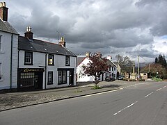
| Main street from Kippen | ||
| Coordinates | 56 ° 8 ′ N , 4 ° 10 ′ W | |
|
|
||
| Residents | 1026 (2011 census) | |
| administration | ||
| Post town | STIRLING | |
| ZIP code section | FK8 | |
| prefix | 01786 | |
| Part of the country | Scotland | |
| Council area | Stirling | |
| British Parliament | Stirling | |
| Scottish Parliament | Stirling | |
| Website: http://www.kippen-village.co.uk/ | ||
Kippen ( Scottish Gaelic : An Ceapan ) is a village in the south of the Scottish Council Area Stirling . It is located around 15 kilometers west of Stirling and 30 kilometers north of Glasgow near the right bank of the Forth on the edge of the Fintry Hills . The Trossachs rise to the northwest in a short distance .
history
In the area around Kippen there is numerous evidence of early settlement that goes back to the Stone and Bronze Ages. These include three earthworks , a Promontory Fort , a Dun , a Cairn and the remains of two medieval moths .
The Erskine clan acquired the land five kilometers northwest of Kippen after the Reformation . The nucleus of today's mansion Cardross House formed a Tower House that was built there in the 16th century. The Dun Eaglais and Gribloch House villas were not built until the 20th century.
Tilting is considered the center of Scottish clay pigeon shooting . For this reason, the shooting competitions of the Commonwealth Games 1986 were held in Kippen.
The "Kingdom of Kippen" arose from an encounter between the local laird John Buchanan and the Scottish King Jacob V. Buchanan became friends with the king, whereupon he had him announced as King of Kippen , even at receptions at Stirling Castle . However, it is just a joke name. A kingdom of Kippen never existed.
Between 1861 and 1881 the population of Kippen fell from 403 to 330. While 494 people lived in Kippen in 1961, the number of inhabitants rose steadily in the following decades. In the 2011 census survey, 1026 inhabitants were registered there.
traffic
The Stirling according Balloch leading A811 runs directly north of the tilting and binds to the location of the highway network. In the east, the M9 and A84 (Stirling - Lochearnhead ), in the north the A873 ( Nyadd - Blairhoyle ) and in the west the A81 ( Glasgow - Callander ) and the A875 ( Killearn - Balfron ) are within a few kilometers.
Individual evidence
- ^ List of Gaelic expressions
- ↑ a b Entry in the Gazetteer for Scotland
- ↑ Scheduled Monument - Entry . In: Historic Scotland .
- ↑ Scheduled Monument - Entry . In: Historic Scotland .
- ↑ Scheduled Monument - Entry . In: Historic Scotland .
- ↑ Scheduled Monument - Entry . In: Historic Scotland .
- ↑ Scheduled Monument - Entry . In: Historic Scotland .
- ↑ Scheduled Monument - Entry . In: Historic Scotland .
- ↑ Scheduled Monument - Entry . In: Historic Scotland .
- ↑ Scheduled Monument - Entry . In: Historic Scotland .
- ↑ Entry on Cardross House in Canmore, the database of Historic Environment Scotland (English)
- ↑ Listed Building - Entry . In: Historic Scotland .
- ↑ Listed Building - Entry . In: Historic Scotland .
- ↑ Information on the Kingdom of Kippen
- ^ Information in the Gazetteer for Scotland
- ↑ 2011 census data

