Kirchberg (Oberweißbach)
| Kirchberg | ||
|---|---|---|
|
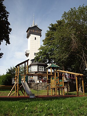
Kirchberg with Froebel Tower and playground |
||
| height | 784.2 m above sea level NHN | |
| location | Thuringia , Germany | |
| Mountains | Thuringian Slate Mountains | |
| Coordinates | 50 ° 34 '36 " N , 11 ° 9' 1" E | |
|
|
||
| particularities | Froebel Tower ( AT ) | |
The Kirchberg near Oberweißbach in the Saalfeld-Rudolstadt district is a 784.2 m high mountain in the Thuringian Slate Mountains . On the summit is the Froebel tower with an attached restaurant.
Geographical location
The Kirchberg is located in the western part of the Thuringian Slate Mountains between Oberweißbach in the northwest, Deesbach in the south and the Deesbach pre-dam in the east.
Traffic and walking
In addition to a road connection from the towns of Oberweißbach and Deesbach, Kirchberg is also easy to reach with the Oberweißbacher Bergbahn . The hike from the final stop of the flat route in Cursdorf takes about 45 minutes.
Various hiking trails lead over the Kirchberg, u. A. The Eisenach – Budapest International Mountain Hiking Trail and the Schwarzatal Panorama Trail
In winter, depending on the weather, a 300 m long drag lift and a toboggan slope are in operation from Oberweißbach .
See also
Web links
Individual evidence
- ↑ a b Map services of the Federal Agency for Nature Conservation ( information )
- ↑ Panoramaweg Schwarzatal on the website of Thüringer Tourismus GmbH

