
Kirchhof and Friedhof Hochkirchen


The churchyard and cemetery in Hochkirchen , Nörvenich municipality , in the Düren district , are two neighboring burial sites.
The historic church cemetery , which has not been used since 1972, is located directly on the south side of the Catholic Church of St. Viktor . To the north-east of it, the new cemetery was laid out in 1968 when the available parcels of the cemetery were no longer sufficient. The old churchyard is a listed building .
The deceased from the whole parish were buried in the churchyard . This includes the places Irresheim , Eggersheim , Dorweiler , Poll and Hochkirchen as well as from Nörvenich Burgstraße, Am Kreuzberg, Oberbolheimer Straße, Vogelgasse, Marktplatz (except No. 2 and 4) and Zülpicher Straße (left side of the street from the corner of Marktplatz to the corner of Kirchgasse ). In Poll and Dorweiler there have been their own chapels and cemeteries since time immemorial . Eggersheimer and Irresheimer are still buried in Hochkirchen today.
In the old churchyard there are 109 old tombs, mostly from the 16th to 18th centuries; the two oldest are from 1586 and were erected in memory of Johann Hoch from Eggersheim and Caspar wirdt from Poll. Such an abundance of old gravestones is nowhere to be found in a wide area.
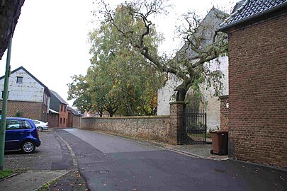
The churchyard has two entrances, one to the east of the church between the Steinfelderhof and the church building through a large wrought-iron gate and a second one to the south via a staircase, next to which there is a mission cross . It was built on the occasion of the people's mission from June 18 to July 2, 1950. On both sides of the entrance there are weathered, barely recognizable stone reliefs in the churchyard wall, which show scenes from the Way of the Cross . The churchyard wall, built from rubble stones , is between 3.10 m and 1.80 m high on the street side and has been repaired with bricks in places. The width is 0.80 m. On the inside, i.e. towards the churchyard, the height is 1.20 m throughout. Only the east and south sides are surrounded by a boundary wall. On the west side, a quarry stone wall supports the area towards the Neffelbach slope . It rises more than 5 m high from the slope and is supported by buttresses. St. Viktor limits the area to the north.
Mathias Köp, born and died in Eggersheim, father of the founder of the Schoenstatt Movement , Josef Kentenich , was buried in the old churchyard. The grave attracted many tourists , but was leveled years ago by the community. In the churchyard there are priest graves with a high stone cross on the southern side of the church tower . A total of four priests were buried there from 1869 to 1974 . The grave complex is covered with tombstones from previous centuries.
On the east side behind the church five uniform war grave crosses were set up for 10 dead from the Second World War . In addition, eight individual graves for dead from both world wars have been preserved.
With the Church of St. Viktor, the churchyard, the old 109 grave crosses and the churchyard wall made of rubble stones were entered in the monument list of the municipality of Nörvenich on March 12, 1985 . It appears in the listing under no.33.
The cemetery, which was newly created in 1968 (Hochkirchen district, corridor 5 no. 1), is 2050 m² in size and has around 500 grave sites, there is a mourning hall and a wooden high cross. The mourning hall was built in 1968/1969 and has a cold store.
Directly at the cemetery on the edge of the parking lot, between two birch trees, there is a road cross from 1859, which was listed on March 14, 1985. Immediately after completion, construction of the mourning hall began. Since then, no more burials have taken place in the churchyard.

The priestly graves

The war graves World War 2
The churchyard wall with a gate in the east

The southern entrance in Kirchstrasse

Gravestone Hoch from 1586


literature
- Karl Heinz Türk : St. Viktor in Hochkirchen . Ed .: Catholic parish of St. Viktor Hochkirchen. Hochkirchen 1993.
- Karl Heinz Türk: Hochkirchen - 900 years of village history in brief . Ed .: Nörvenich municipality. Hochkirchen 2002.
- Karl Heinz Türk: Small Christian monuments in Börde and Neffeltal . Ed .: Karl Heinz Türk. Rheinland-Verlag Cologne, Hochkirchen 1979, ISBN 3-7927-0490-0 .
Individual evidence
- ↑ Karl Heinz Türk, Nörvencher Families, Houses and Courtyards , Nörvenich 2006, p. 71
- ↑ Personal data on historical gravestones in cemeteries between Börde and Neffeltal in the Dürener Land , compiled by Kurt Baltus, Düren, who is based on small Turkish monuments (PDF; 33 kB)
- ↑ Entry with pictures on ehrenmale-kreis-dueren.de
Web links
Coordinates: 50 ° 47 ′ 54.9 " N , 6 ° 38 ′ 25.5" E