Klein Jauer (Altdöbern)
|
Klein Jauer
Altdöbern municipality
Coordinates: 51 ° 38 ′ 15 ″ N , 14 ° 3 ′ 32 ″ E
|
|
|---|---|
| Incorporation : | July 1, 1950 |
|
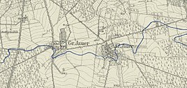
Groß Jauer and Klein Jauer on a measuring table sheet from 1912
|
|
Klein Jauer ( Jaworka in Lower Sorbian ) was part of the Altdöbern community in what is now the Oberspreewald-Lausitz district . The place was demolished in 1985 in favor of the Greifenhain open-cast lignite mine and the 116 inhabitants of the place were resettled.
location
Klein Jauer was in Niederlausitz , southeast of Altdöbern . The local area was demolished in the years 1985 to 1986 by the Greifenhain opencast mine in favor of lignite extraction. Surrounding villages were Neudorf in the north, Pritzen in the northeast, Kunersdorf in the southeast, Woschkow in the south, Groß Jauer in the west and Altdöbern in the northwest. Klein Jauer was on a connecting road between Altdöbern and Neupetershain .
history
Klein Jauer was first mentioned in a document on July 22, 1377. It originally called the place name Small Jaworka , he's from the Lower Sorbian word jawor for " Maple " derived. Until 1635, Klein Jauer belonged to the Lower Lusatia margraviate and was thus part of the Bohemian crown lands . Through the Peace of Prague , the place finally came to the Electorate of Saxony .
From 1806, Klein Jauer belonged to the newly formed Kingdom of Saxony . After the Congress of Vienna and the division of the Kingdom of Saxony decided there, Klein Jauer came to the Kingdom of Prussia together with the entire Lower Lusatia . From the territorial reform carried out in 1816, the place belonged to the district of Calau in the province of Brandenburg . The Klein Jauer manor, together with the Muckwar manor, was subordinate to the noblemen on Altdöbern and had to submit an estimate of 700 guilders. The area of the estate was unknown, but there was no manorial property. In 1844 there were 20 residential buildings in Klein Jauer, the place had 89 inhabitants and was parish to Altdöbern. In 1852 Klein Jauer had 124 inhabitants, making the place larger than the neighboring Groß Jauer. In 1867 Klein Jauer had 132 inhabitants and there was a brick factory and a water mill.
At the census of December 1, 1871, the population of the rural community Klein Jauer was made up as follows: There were 25 families and 128 inhabitants, 65 of whom were male and 63 were female. 32 residents were younger than ten years and all residents in Klein Jauer were Evangelical Lutheran denominations. In 1875 Klein Jauer had 130 inhabitants. In the census of December 1910, 141 inhabitants were counted in Klein Jauer. After the end of the Second World War , the lords of Witzleben-Alt-Doebern , who most recently owned the manor over Klein Jauer, were expropriated and the land was divided up among new farmers . In the Soviet occupation zone and from 1949 in the GDR, Klein Jauer remained in the Calau district.
On July 1, 1950, the district of Calau was renamed Senftenberg. On the same day, Klein Jauer was incorporated into Altdöbern. During the GDR district reform on July 25, 1952, the place became part of the Calau district in the Cottbus district . In the 1980s, the Greifenhain open-cast lignite mine reached Klein Jauer. By 1985 the last 116 inhabitants of the village had been resettled, Klein Jauer was demolished the following year and the land was claimed by the opencast mine. In 1992 the opencast mine was stopped and the remaining hole flooded. The Altdöberner See is located on the site of the former village . In administrative terms, the former district of Klein Jauer is now part of the Oberspreewald-Lausitz district in Brandenburg.
See also
literature
- Documentation of relocations due to mining , archive of lost places, Forst / Horno, 2010
Web links
- Archive of disappeared places
- Klein Jauer / Jaworka in the archive of missing places
- Lignite mining and rehabilitation in the Greifenhain / Gräbendorf area , Lausitzer- und Mitteldeutsche Bergbauverwalungsgesellschaft, 2005
proof
- ↑ Klein Jauer / Jaworka in the archive of lost places. In: archiv-verschwundene-orte.de. Retrieved April 1, 2017 .
- ↑ The park has been organized for 50 years. In: lr-online.de. Lausitzer Rundschau , December 28, 2007, accessed on April 1, 2017 .
- ↑ Reinhard E. Fischer : The place names of the states of Brandenburg and Berlin. Age - origin - meaning . be.bra Wissenschaft, Berlin 2005, p. 83 .
- ^ Heinrich Berghaus : Land book of the Mark Brandenburg and the Markgrafthum Niederlausitz in the middle of the 19th century. Becker, Potsdam / Brandenburg 1856, p. 572 ( online ).
- ↑ Topographical-statistical overview of the government district of Frankfurt ad O. Gustav Harnecker's bookstore, Frankfurt a. O. 1844 Online at Google Books , p. 23.
- ↑ Topographical overview of the appellate court department Frankfurt a / O. Publishing house by Gustav Harnecker u. Co. 1856, p. 127 ( online ).
- ↑ Topographical-statistical manual of the government district of Frankfurt a. O. Verlag von Gustav Harnecker u. Co., 1867 Online at Google Books , p. 26.
- ↑ Royal Statistical Bureau: The communities and manor districts of the Prussian state and their population . Part II: Province of Brandenburg , Berlin 1873, pp. 210f., No. 59 ( online ).
- ↑ Klein Jauer / Jaworka. Archives of Lost Places, accessed June 15, 2020.
