Knížecí Pláně
| Knížecí Pláně | ||||
|---|---|---|---|---|
|
||||
| Basic data | ||||
| State : |
|
|||
| Region : | Jihočeský kraj | |||
| District : | Prachatice | |||
| Municipality : | Borová Lada | |||
| Area : | 1196 ha | |||
| Geographic location : | 48 ° 57 ' N , 13 ° 37' E | |||
| Height: | 1020 m nm | |||
| Residents : | 0 (2011) | |||
| Postal code : | 385 01 | |||
| License plate : | C. | |||
| traffic | ||||
| Street: | Borová Lada - Knížecí Pláně | |||
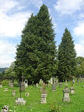
Knížecí Pláně (German prince hat ) is a district of the municipality Borová Lada in Okres Prachatice , Czech Republic .
geography
The abandoned village is located a few hundred meters from the German-Czech border in the Šumava National Park . The closest village was the Buchwald (Bučina) , which also no longer exists today . Today the next villages on the Czech side are Borová Lada (German Ferchenhaid, approx. 6 km) and Kvilda (German Aussergefild, 7 km) in the northeast . About four kilometers as the crow flies in the southwest on the German side is Finsterau . From there it is possible to reach Knížecí Pláně via the border crossing Finsterau / Buchwald, which is closed to motor vehicles. From the Czech side, Knížecí Pláně can be reached via several hiking and cycling trails.
history
The village was created in 1792 in the course of several local foundings by the Prince of Schwarzenberg . At that time they were based in Krummau, about 50 kilometers away . The village at that time had almost 70 buildings and housed more than 500 residents. In 1864 the church named after John the Baptist (Jan Křtitel in Czech) was opened. After the Second World War , the predominantly German population was expelled in 1946 and the buildings were demolished by 1956. The church and the cemetery were also destroyed. For the next few decades the place was in the exclusion zone on the border with Germany and was not accessible to the public. The position was only accessible again after the political change. In 1992 the former residents were given permission to erect the tombstones in the cemetery and to renovate the complex. The rubbish heap of the church is covered with trees. The wooden cross erected in place of the church was destroyed in a storm in 2007 and replaced by a smaller one. There is only one house in Knížecí Pláně.


