Koslow (Kieferstädtel)
| Koslow Kozłów |
||
|---|---|---|
 Help on coat of arms |
|
|
| Basic data | ||
| State : | Poland | |
| Voivodeship : | Silesia | |
| Powiat : | Gliwice (Gliwice) | |
| Gmina : | Kieferstädtel | |
| Geographic location : | 50 ° 18 ' N , 18 ° 34' E | |
| Residents : | ||
| Telephone code : | (+48) 032 | |
| License plate : | SGL | |
| Economy and Transport | ||
| Next international airport : | Katowice | |
Koslow (Polish: Kozłów ) is a village in Upper Silesia . It is located in the municipality of Kieferstädtel in the Powiat Gliwicki (district of Gliwice) in the Silesian Voivodeship .
geography
Koslow is about three kilometers northeast of the township Kieferstädtel , nine kilometers west of the district town Gliwice ( Gleiwitz ) and 33 kilometers west of the voivodeship capital Katowice ( Kattowitz ).
history
The place originated in the 13th century at the latest and was first mentioned in a document in 1279.
In 1633, a Swedish corps with 20,000 men camped in the village's fields for six months. From there they attacked the city of Gliwice.
The place was mentioned in 1783 in the book Beytrage to describe Silesia as Ceslow , consisted of two parts and was in the district of Tost . One part had 248 inhabitants, two farms, a Catholic church, a mill, 18 farmers and 19 gardeners. The other part had 46 inhabitants, a farm, five farmers and ten gardeners. In 1818 the place was mentioned as Ceslow . In 1865 Kozlow consisted of a manor and a village. The manor consisted of three parts named Kozlow I, Kozlow II and Kozlow III and had four Vorwerk with the names Kozlow-Oberhof, Kozlow-Niederhof, Waldvorwerk and Carlowitz. The village also consisted of three parts and was united into one community a few years earlier. At that time the village had 18 farmers, 26 gardeners and 30 cottagers. There was also a copper hammer, two grinding mills, a cutting edge, a Catholic church and a Catholic school with 130 students. The copper hammer was originally an ironworks.
In the referendum in Upper Silesia on March 20, 1921, 118 eligible voters voted for Upper Silesia to remain with Germany and 475 for membership in Poland. After the partition of Upper Silesia, Koslow remained with the German Empire . On February 12, 1936, the place was renamed Lindenhain / Upper Silesia in the course of a wave of renaming during the Nazi era . Until 1945 the place was in the district of Tost-Gleiwitz .
In 1945 the formerly German town came under Polish administration and was then attached to the Silesian Voivodeship and renamed Kozłów in Poland . In 1950 the place came to the Katowice Voivodeship . In 1999 the place came to the re-established Powiat Gliwicki and the new Silesian Voivodeship. On October 10, 2013, the place was also given the official German place name Koslow .
Attractions
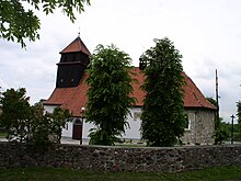
- Roman Catholic Church of St. Nicholas from the 16th century
- Chapels
education
- A kindergarten and a primary school
Individual evidence
- ^ Johann Ernst Tramp: Additions to the Description of Silesia, Volume 2 , Brieg 1783
- ^ Geographical-statistical handbook on Silesia and the county of Glatz, Volume 2 , 1818
- ↑ Felix Triest: Topographisches Handbuch von Oberschlesien , Breslau 1865
- ^ Results of the referendum in Upper Silesia of 1921: Literature , table in digital form ( Memento from January 15, 2017 in the Internet Archive )


