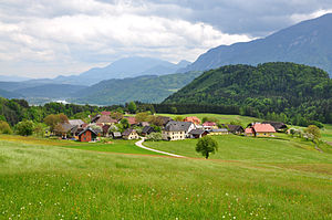
Kossiach
|
Kossiach / Kozje ( Rotte ) village |
||
|---|---|---|
|
|
||
| Basic data | ||
| Pole. District , state | Klagenfurt-Land (KL), Carinthia | |
| Judicial district | Klagenfurt | |
| Pole. local community | Ebenthal in Carinthia ( KG Hinterradsberg) | |
| Coordinates | 46 ° 33 '57 " N , 14 ° 23' 6" E | |
| Residents of the village | 58 (January 1, 2020) | |
| Statistical identification | ||
| Locality code | 00986 | |
| Counting district / district | Radsberg (20402 003) | |

|
||
| Source: STAT : index of places ; BEV : GEONAM ; KAGIS | ||
Kossiach ( Slovenian Kozje ) is a small village in the market town of Ebenthal in Carinthia in the Klagenfurt-Land district in Carinthia . Kossiach has 58 inhabitants (as of January 1, 2020).
geography
The former Großweiler lies on the southern edge of the eastern Sattnitz. Part of the plateau of Radsberg has broken off here. The demolition from the northern field of Schwarz in around 780 m to the field of Kossiach in around 650 m is more than 200 m. To the south, the Sattnitz conglomerate table breaks off again steeply with approx. 200-300 m to the river. The village is surrounded by large forests. The use of firewood and the sale in Klagenfurt have been an important additional source of income for the farmers for centuries.
history
In 1321 Niklaus von Eberstein sells a hat to Kossiach to Hermann the "Scoedil", servant of the Schenken von Osterwitz. His successors sold this Hube again around 50 years later. In 1488, the Viktring Abbey appears here with 2 ½ manses. Thomas and Jakob and his son of the same name are the owners. In 1496 and 1515 there are 4 hubs on which two farmers sit: Clement and Thomas, each of whom serves two hubs. Two of these are used for the “Skodl anniversary”. They seem to have come to Viktring through a gift from one of the descendants of Hermann Scoedil. As with Schwarz, Viktring has also preserved its property here when it had to sell the fourth part of its property in 1529 because of the Turkish tax. In 1549 an Urban Clement and a Ruprecht Quder, son of a Lukas, serve from 1 ½ Huben each to Viktring. Since the ownership structure, at least as far as Viktring is concerned, has evidently remained very stable and, moreover, in such early times the owner's name and house name mostly go hand in hand, i.e. are quite interchangeable, we also find two Huben, Pettnig and Queder, belonging to Viktring in 1827, it is at these courtyards with great certainty around today's courtyards vlg. Pettig and Queder. In 1672 a "Millian" (= today vulgo Mellan) serves from a Hube to Ebenthal. 1682 an Urban Rogaunig or Millian sits here, who serves from the Millianhube. In 1744 Simon Rogaunig dies and the completely decrepit farm goes to Valentin Oblak. At that time a Lukas Pogoriutschnig appeared as a Grafensteiner and a Thomas Oblack (Pettig) as a Viktringer subject.
In 1827 we find the following relationships of subjects:
- Grafenstein has the famous Pogoriutschnig, with the Pogoriutschnig Zulehen belonging to the Radsberg rectory, as well as Sedlischnig (K 14), Janasch (K 16) and Srepou (K 18)
- In addition to the Zulehen, the Radsberg rectory also has Lipusch (K 4) and Oblak (K 8)
- Viktring has the vlg. Pettig (K 5) and Queder (K 10)
- Ebenthal has the vlg. Mellan (K 11)
- Welzenegg the vlg. Strutz (K 12)
- Gut Metnitz has the Pader (K 15)
economy
In 1973 there were a total of 12 houses in Kossiach, two of which were workers' houses. Only agriculture was practiced in the village: arable farming, grassland farming and livestock farming. At that time there were 9 farms, of which 6 were full-time farms, 2 were part-time and 1 part-time farms. One company, K 11, had run out and had leased its fields.
Field corridor
In the field of Kossiach, large, completely irregular fields alternate with smaller rectangular ones. There is a clear differentiation between the corridors of the 7 courtyards that make up the hamlet itself and those outside. While the block corridor of the hamlet is mixed up, the farms outside are entirely deserted. This can be a block corridor, like the large corridor of the vlg. Pogoriutschnig, but it can also be irregularly striped, like that of the vlg. Janasch or Pader. The Sprep chaste obviously belongs to a very late phase and arose on church grounds. Correspondence in correspondence with K5 and K11 and K4 and K8 obviously indicates yard divisions. It is also possible that K12 and K14 did not emerge from K10 until the courtyard was later divided, because they are the only courtyards in the hamlet that do not have a courtyard connection to their plots. This is them through the hallway of the vlg. Queder denied.
literature
- Klaus Arnold: The eastern Sattnitz. The problem of a stagnating agricultural area in the outskirts of Klagenfurt. Diss. The Univ. Vienna, 2 vol., Vol. 131/1 and 2, Association of Austrian Scientific Societies, Vienna 1976
- Klaus Arnold: The eastern Sattnitz - mountain farming area at the gates of Klagenfurt. Amaliendorf 2012. CD and online access at arnold-research.eu
Individual evidence
- ↑ Statistics Austria: Population on January 1st, 2020 by locality (area status on January 1st, 2020) , ( CSV )
- ↑ MC, Vol. 8, 568
- ↑ Quoted from Fresacher, Part I, p. 70 - Urk. A456, GV
- ↑ Urbar Viktring, KLA 3/16
- ↑ Urbar Viktring, KLA No. 2512
- ↑ Urbar Viktring, KLA 1164
- ^ AG, HS 63
- ↑ AG, AHS, No. 111, p. 174
