Kotorosl
|
Kotorosl Которосль |
||
|
The Savior Transfiguration Monastery on the Kotorosl in Yaroslavl |
||
| Data | ||
| Water code | RU : 08010300212110000010644 | |
| location | Yaroslavl Oblast ( Russia ) | |
| River system | Volga | |
| Drain over | Volga → Caspian Sea | |
| Confluence of |
Ustje and Wjoksa 57 ° 14 ′ 45 ″ N , 39 ° 31 ′ 33 ″ E |
|
| muzzle | in the Volga in Yaroslavl Coordinates: 57 ° 36 ′ 58 " N , 39 ° 54 ′ 21" E 57 ° 36 ′ 58 " N , 39 ° 54 ′ 21" E
|
|
| length | 126 km (including Wjoksa: 132 km; including Ustje: 279 km) | |
| Catchment area | 6370 km² | |
| Drain |
MQ |
30 m³ / s |
| Left tributaries | Pachma | |
| Right tributaries | Laughter | |
| Big cities | Yaroslavl | |
| Medium-sized cities | Gavrilov Jam | |
|
Kotorosl in Yaroslavl |
||
The Kotorosl ( Russian Которосль ) is a river in the European part of Russia and a right tributary of the Volga .
general description
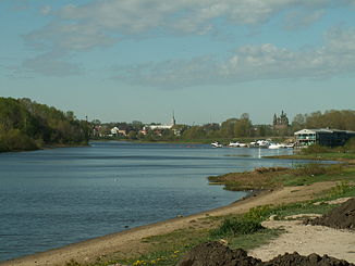
The 126 km long and at normal water level up to about 60 meters wide flows through the Yaroslavl Oblast and flows into the Volga in the center of the city of Yaroslavl , which, according to the city's founding legend, arose exactly at the mouth of the Kotorosl. The origin is near the city of Rostov , where the Kotorosl is formed by the confluence of its source rivers Ustje and Vjoksa (the latter is an outflow of Lake Nero ). During floods , which usually occur in April or May, the width of the river can be up to a kilometer in some places.
For a large part of its course, including within Yaroslavl before the mouth, the Kotorosl is very rich in loops , only downhill from the town of Gavrilow-Jam it flows in places through a straight valley. Even in the urban area of Yaroslavl, the banks of the Kotorosl - apart from a section of the left bank at the height of the historic city center , where there is also a waterfront promenade - are not built up and are comparatively natural.
The Kotorosl is not navigable, but is often used by small private boats in the summer months. The landscapes on their banks are considered attractive and are a popular local recreation area with dachas and sanatoriums .
etymology
The hydronym Kotorosl, also known as Kotorost before the 20th century , could come from the Finno-Ugric language of the Merja , the people who settled large parts of what is now central Russia in the first millennium AD: Some researchers suspect that Kotorosl dated Merja word for "loopy river" was derived. The other popular version claims a purely Russian origin of the hydronym: Kotorost from kotoratsja , an outdated verb for "quarrel" or "argue". Accordingly, the two rivers Ustje and Wjoksa, from which the Kotorosl emerges, “argue” which of the two is the real Kotorosl and which is just a tributary.
Web links
- On the Etymology of the Kotorosl (Russian)
- Historical Brockhaus entry (Russian)

