
Krottenbach (Dürrach)
| Krottenbach | ||
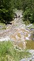
 Bridge over the Krottenbach near the end of the valley |
||
| Data | ||
| Water code | DE : 161524 | |
| location | Bad Tölz-Wolfratshausen district , Bavaria ( Germany ), and Tyrol ( Austria ) | |
| River system | Danube | |
| Drain over | Dürrach → Isar → Danube → Black Sea | |
| source | east below the Tölzer Hütte 47 ° 30 ′ 16 ″ N , 11 ° 29 ′ 49 ″ E |
|
| Source height | approx. 1752 m | |
| muzzle |
Dürrach coordinates: 47 ° 33 ′ 4 " N , 11 ° 32 ′ 20" E 47 ° 33 ′ 4 " N , 11 ° 32 ′ 20" E |
|
| Mouth height | 767 m | |
| Height difference | approx. 985 m | |
| Bottom slope | approx. 11% | |
| length | 9 km | |
| Catchment area | 18.67 km² | |
| Left tributaries | Moosbach , Oedbach | |
The Krottenbach is a year-round flowing water in the Karwendel on Austrian and German territory.
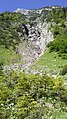
It arises in the depression between Delpsjoch and Östlicher Torjoch on Tyrolean territory, and after a short eastern course it forms the Delpssee there . The brook leaves the lake on its north side and then falls steeply into the valley head of the Krottenbachtal between Westlicher Torjoch and Stierjoch in Bavarian territory. In the Krottenbachtal, the stream runs through several gorge-like sections, taking in the water from the tributaries in the valley basin. At the Griesmann Niederleger , he makes a bend to the east. After another gorge, which has been designated a natural monument, the Krottenbach finally flows into the Dürrach from the west.
Alpinism
One of the approaches to the Schafreiter runs through the Krottenbachtal, which is largely inaccessible to vehicles . The creek is also used by canoe.
gallery

Tributary Oedbach
Tributary Moosbach
Nameless tributary from the Lichteck

.jpg)

Individual evidence
- ↑ Roughly measured in the BayernAtlas
- ↑ Directory of creek and river areas in Bavaria - Isar river area, page 7 of the Bavarian State Office for the Environment, as of 2016 (PDF; 2.5 MB)
- ↑ Klammerlebnis Krottenbach , Lindau white water paddler