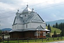
Kryvopillja
| Kryvopillja | ||
| Кривопілля | ||

|
|
|
| Basic data | ||
|---|---|---|
| Oblast : | Ivano-Frankivsk Oblast | |
| Rajon : | Verkhovyna Raion | |
| Height : | 960 m | |
| Area : | 59 km² | |
| Residents : | 959 (2004) | |
| Population density : | 16 inhabitants per km² | |
| Postcodes : | 78706 | |
| Area code : | +380 3432 | |
| Geographic location : | 48 ° 12 ' N , 24 ° 42' E | |
| KOATUU : | 2620885001 | |
| Administrative structure : | 3 villages | |
| Address: | 78706 с. Кривопілля | |
| Statistical information | ||
|
|
||
Krywopillja ( Ukrainian Кривопілля , Russian Кривополье Kriwopolje , Polish Krywopole ) is a village in the east of the "Black Mountains" in the south of the Ukrainian Oblast Ivano-Frankivsk with about 1000 inhabitants (2004).
The village, founded by Hutsuls in 1899 , is the administrative center of the district council of the same name in the north of Verkhovyna district , which also includes the villages of Stajishche ( Стаїще ⊙ ) with about 240 inhabitants and Wolowa ( Волова ⊙ ) with about 230 inhabitants.
Kryvopillja is located 2 km southeast of the Kryvopillja pass named after the place , a mountain pass of the Forest Carpathians , over which the regional road Р-62 leads from Vorokhta in the valley of the Prut 18 km in the northwest to the district center Verkhovyna in the valley of the Chornyj Cheremosh 16 km in the southeast .
Krywopillja is located 105 km south of the Oblast capital Ivano-Frankivsk .
Web links
- Kryvopillja on karpaty.info (Ukrainian)
- Krywopillja on ikc.if.ua (Ukrainian)
Individual evidence
- ↑ Krywopillja on castles.com.ua ; accessed on June 26, 2017 (Ukrainian)
- ↑ Kryvopillja Pass on turizm-karpaty.com.ua ; accessed on June 27, 2017 (Ukrainian)


