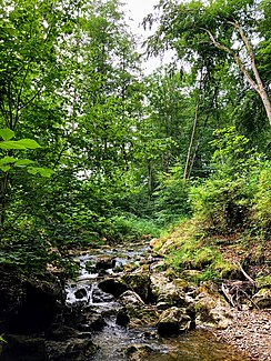
Kuglmühlbach
| Kuglmühlbach | ||
|
Kuglmühlbach near the confluence with the Starnberger See |
||
| Data | ||
| location | Upper Bavaria | |
| River system | Danube | |
| Drain over | Starnberger See → Würm → Amper → Isar → Danube → Black Sea | |
| source | Schellenbergmoor nature reserve 47 ° 50 ′ 43 ″ N , 11 ° 22 ′ 6 ″ E |
|
| Source height | 676 m above sea level NHN | |
| muzzle | in the Starnberger See near Ambach Coordinates: 47 ° 52 '21 " N , 11 ° 19' 56" E 47 ° 52 '21 " N , 11 ° 19' 56" E |
|
| Mouth height | 584 m above sea level NHN | |
| Height difference | 92 m | |
| Bottom slope | approx. 18 ‰ | |
| length | approx. 5 km | |
The Kuglmühlbach in Upper Bavaria is a tributary to Lake Starnberg on its southeast side.
The brook arises in the Schellenbergmoor , flows as a boundary ditch in a largely north-westerly direction and flows from the east into the Starnberger See near Ambach .
In its course the brook feeds the mills ball mill and the strobel mill .
Web links
- The course of the Kuglmühlbach on the BayernAtlas
