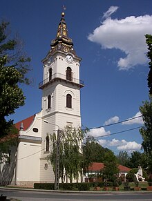
Kunszentmiklós
| Kunszentmiklós | ||||
|
||||
| Basic data | ||||
|---|---|---|---|---|
| State : | Hungary | |||
| Region : | Southern Great Plain | |||
| County : | Bács-Kiskun | |||
| Small area until December 31, 2012 : | Kunszentmiklós | |||
| District since 1.1.2013 : | Kunszentmiklós | |||
| Coordinates : | 47 ° 2 ' N , 19 ° 7' E | |||
| Area : | 172.11 km² | |||
| Residents : | 8,628 (Jan 1, 2011) | |||
| Population density : | 50 inhabitants per km² | |||
| Telephone code : | (+36) 76 | |||
| Postal code : | 6090 | |||
| KSH kódja: | 28130 | |||
| Structure and administration (as of 2015) | ||||
| Community type : | city | |||
| Mayor : | Árpád Lesi (Fidesz-KDNP) | |||
| Postal address : | Kálvin tér 12 6090 Kunszentmiklós |
|||
| Website : | ||||
| (Source: A Magyar Köztársaság helységnévkönyve 2011. január 1st at Központi statisztikai hivatal ) | ||||
Kunszentmiklós (German Sankt Niklas ) is a city and administrative center of the same small area in County Bács-Kiskun about 60 kilometers south of Budapest in Hungary . The population is almost 9,000 (as of 2010) on an area of 172.11 km².
Twin cities
Personalities
- József Thury (1861–1906), linguist and Turkologist
Web links
Commons : Kunszentmiklós - collection of images, videos and audio files


