Kuntzow
Kuntzow is a district of the Bandelin community in the Vorpommern-Greifswald district .
geography
Kuntzow is located 2 km west of Bandelin, near the federal motorway 20 , and can be reached in 4 km via the Gützkow exit. The district of the place goes up to the Peene in the southwest. The place is crossed by the K 6 in the direction of Görmin. A farm road - named Peenestraße - runs south to the Peene. The border to the municipality of Görmin and the Peenetal-Loitz office is formed by the Kuntzower Bach, which forms a channel as a glacial washout. The Bandeliner Os runs east of the village and is wooded here from the village to the road to Schmoldow.
history
Kuntzow was mentioned in a document with its current name in 1406. The place name Kuntzow is probably due to the Slavic word kuniza - marten , it was a Slavic settlement.
According to the records of the Swedish Land Registry of Western Pomerania , Kuntzow was in the middle ages in the feudal possession of a noble family Draken . After their extinction, the fief fell back to the Pomeranian ducal house . From 1582 there are documents in which the Chamber Councilor Melchior Normann was enfeoffed by Duke Ernst Ludwig von Pommern-Wolgast with the estate “in respect of his services rendered”. In 1670 the male line of the West Pomeranian branch of von Normann went out , the daughter Anna Sophia married the lieutenant Bogislav Adam von Heyden and received the estate until 1690. In that year it was pledged to Christian Corswandt, but this was not recognized. However, it was later given to the Corswandt family , and from 1702 it remained in their possession. The Corswandt's were ennobled by Emperor Leopold I in 1694 .
The size of the estate was stated on April 10, 1866 as follows: arable land 1364 acres , meadows 173 acres, pasture 76 acres, gardens 17 acres, woodland 221 acres, courtyard, paths and churchyard 73 acres, bleach and unland 1 acre, whole field marrow 1925 morning. On January 1st, 1865 there were 149 inhabitants in Kuntzow, including 20 families, 1 owner with 6 relatives, 6 administrators and assistants, 1 housekeeper, 11 servants and boys, 4 maids, day laborers - 11 male and 12 female, 1 craftsman, servants - 3 male and 2 female. On buildings: 1 church, 9 residential buildings, 12 farm buildings and 2 designated as factory buildings (a forge, a mill). The estate was owned by District Deputy Carl von Corswandt since 1823. In 1905 a post mill is also listed.
Kuntzow became notorious in the 1920s and 1930s because Walther von Corswant, the Pomeranian Gauleiter of the NSDAP, had his seat here. He founded the local groups of the party in the whole area, as well as the notorious SA-Sturm 77. Because of his sometimes extreme and deviating views, the Gauleitung was withdrawn from him, he became district administrator of the district of Greifswald . He fell in the war in 1943.
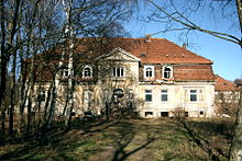
The Corswants have always managed the estate themselves. The last owner died in 1945, his son Walther died in the war, the other left the Soviet occupation zone with his mother . The graves of the Corswants are in the churchyard and there is also a burial place in the chapel . The classicist manor house from around 1812 stood empty for many years and was left to decay. The building is currently being restored by an investor from Bavaria.
On December 31, 2014, Kuntzow had 72 residents with a main residence and 4 with a secondary residence.
On December 31, 2015, Kuntzow had 77 residents with a main residence and 4 with a secondary residence.
Attractions
Buildings
- Manor Kuntzow, ruinous
- Kuntzow Chapel
Green areas and local recreation
- The “Kuntzower Bach” flows through the park in a loop, but it is neglected and overgrown. This brook has washed out a charming valley that stretches all the way to the Peene.
- In the direction of Bandelin, the Bandeliner Os extends from Gut Kuntzow, which is wooded here by the village up to the road to Schmoldow.
- At the Peene there are several peat cuttings in the area, which are now used by anglers. The place is connected to the place by a farm road (called Peenestrasse).
literature
- Heinrich Berghaus : Land book of the Duchy of Pomerania and the Principality of Rügen. IV. Part Volume II, Anklam 1868, pp. 134 and 225 ( Google Books ).
- Werner Wöller: Villages of the community association Gützkow. typed, 1983
- Manfred Niemeyer: East Western Pomerania. Collection of sources and literature on place names. Vol. 2: Mainland. (= Greifswald contributions to toponymy. Vol. 2) , Ernst-Moritz-Arndt University of Greifswald, Institute for Slavic Studies, Greifswald 2001, ISBN 3-86006-149-6 . Pages 77, 120
Individual evidence
- ^ Manfred Niemeyer: Ostvorpommern . Collection of sources and literature on place names. Vol. 2: Mainland. (= Greifswald contributions to toponymy. Vol. 2), Ernst-Moritz-Arndt University of Greifswald, Institute for Slavic Studies, Greifswald 2001, ISBN 3-86006-149-6 . P. 40 ff
- ^ Translation: Kuntzow. (No longer available online.) In: Svea-Pommern. Maps and texts from the Swedish Land Survey of Pomerania 1692–1709. Archived from the original on January 9, 2014 ; accessed on January 9, 2014 . Info: The archive link was inserted automatically and has not yet been checked. Please check the original and archive link according to the instructions and then remove this notice.
- ↑ Late rescue for the Kuntzower estate ensemble. Retrieved January 2, 2019 .
- ^ Züssow office, residents of the Züssow administrative area, as of December 31, 2014
- ^ Züssow Office, residents of the Züssow administrative area, as of December 31, 2015
Web links
Coordinates: 53 ° 58 ' N , 13 ° 21' E


