
Kuranda
| Kuranda | |||||||
|---|---|---|---|---|---|---|---|
 Kuranda Railway Station |
|||||||
|
|||||||
|
|||||||
|
|||||||
|
|||||||
|
|||||||
|
|||||||

Kuranda is a small town in northern Queensland , Australia . It is a tourist place and has about 2000 inhabitants.
geography
location
The city lies on the Barron River on the western side of the Kuranda Range, part of the Great Dividing Range , averaging 380 meters above sea level. It is enclosed by the rainforest and is located 25 kilometers northwest of Cairns in the local administrative area (LGA) Tablelands Regional Council .
climate
.Australien.png)
Kuranda has a tropical climate. The humidity is not as high as in Cairns, because the place is higher. The maximum temperatures can reach around 37 ° C in the period from November to April. In the remaining months the temperatures drop a little and the humidity is also lower. Due to its location in the rainforest, Kuranda experiences only slight temperature fluctuations. There is a rainy and a dry season.
history
The Tjapukai Aborigines lived in the rainforest around Kuranda 10,000 years ago . The area has been explored by Europeans since the early 19th century. Gold prospectors and loggers moved to the region. A first settlement was established in 1885. Three years later a survey was carried out by Thomas Behan.
Construction of the Cairns to Herberton railroad began in 1882 and reached Kuranda in 1891. Along with the road to the port in Cairns, the cornerstone for trade and growth was laid. Due to the well-suited altitude of 380 meters, coffee cultivation began in some places until the entire harvest was destroyed by frost at the beginning of the 20th century. However, tin mining and timber production continued.
Kuranda became a destination for local holidaymakers and was particularly popular with honeymoon couples. The word had spread about the beauty of the Barron Falls and the rainforest. The station building, which is still in use today, was built in 1915. During the Second World War, troops were stationed in the region and military use took precedence over tourism.
The Barron Gorge Hydroelectric Power Station was commissioned in 1963. Even today, 60 megawatts of electricity are produced there with two generators. In the 1970s the village was discovered by hippies and some hippie communes developed. Local products and handcrafted goods were sold in open-air market stalls. Kuranda flourished during this time and experienced a surge in population.
Attractions
The places of interest include the two travel options with the Skyrail Rainforest Cableway, built in 1995, and with the Kuranda Scenic Railway . The Skyrail Rainforest Cableway is a 7.5 kilometer cable car that starts from the Caravonica Terminal near Cairns. The trip takes 1.5 hours and leads a few meters over the rainforest. The Kuranda Scenic Railway runs from Cairns Station to Kuranda Station in 1.75 hours. The route has remained unchanged since 1891.
There are several sights in the village itself. This includes the various markets and art shops. There is also a bird park, a butterfly hatchery and a noctarium where nocturnal animals can be seen. On the northern edge of the village, not far from Therwine Street, the much-visited wreck of a Japanese plane that crashed in World War II can be seen in the thicket. The Anglican Saint Savior's Church , built in 1915, stands on Coondoo Street, the town's main street lined with sweeping, shady trees , while the Catholic Church of Saint Christopher's Church on Barang Street can be visited. The station building, surrounded by dense tropical vegetation, was completed in 1915. In the immediate vicinity of Kuranda there are various hiking trails and viewpoints, including the Barron Falls .

Stand with art objects

Barron Falls
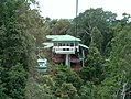
View from the Skyrail gondola to an intermediate station


Web links
Individual evidence
- ↑ a b Australian Bureau of Statistics : Kuranda ( English ) In: 2016 Census QuickStats . June 27, 2017. Retrieved April 14, 2020.
- ↑ Christopher Wright: Saint Savior's Church Kuranda - History and Guide , p. 5. Kuranda 2018