Lübau
|
Lübau
City of Rabenau
Coordinates: 50 ° 57 ′ 16 ″ N , 13 ° 37 ′ 13 ″ E
|
|
|---|---|
| Height : | 325 (300-350) m |
| Incorporation : | 1st January 1974 |
| Postal code : | 01734 |
| Area code : | 0351 |
|
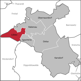
Location of Lübau in Rabenau
|
|
Lübau is a district of Rabenau in the Saxon district of Saxon Switzerland-Eastern Ore Mountains .
geography
Lübau is a forest hoof village that extends in a north-easterly direction from a plateau to the Borlasbach . The place is about 330 m above sea level and is located on the lowest edge of the Eastern Ore Mountains . Approx. 300 residents (2004) live in the Lübau district.
location
| Somsdorf | Sdlg. Waldviertel | Rabenau |
| Noble crown |

|
Spechtritz |
| Borlas |
history
The first written mention under the name Lobouwe goes back to the year 1378. Until 1569 the manor belonged to the Rabenau manor, after which it was the district of the Dippoldiswalde district , where it was mostly written as Liebau. Lübau was parish to Somsdorf until 1930 , then to Rabenau.
Lübau belonged to the Dippoldiswalde office until 1843, then to the Tharandt court office . From 1875 Lübau was part of the Dresden administration and joined the Freital district in 1952 . In 1974 Lübau was incorporated into the town of Rabenau. According to the Saxon municipal code, there is a local council with a local mayor for local issues .
The Lübauer Mühle am Borlasbach is mentioned for the first time in 1830, it is no longer in operation. The school was built in 1833 and was used as a municipal office from 1953 until it was incorporated. The village inn burned down in 1970, and in 1840 chair making in the village with four chair makers and 3 assistants is mentioned. In 1944, refugees from East Prussia were quartered with the farmers in Lübau.
In 1952 the LPG friendship was founded. Machine halls, warehouses and open stables were built at the upper and lower end of the town. In the 1980s, a modern bull fattening facility was built at the lower end of the village, which today houses young cattle breeding and a biogas plant for Dresdner Vorgebirgs Agrar AG.
Development of the population
Source: Institute for Saxon History and Folklore
|
|
Personalities
- E. Jochen (* 1812 in Dresden, † 1833 in Lübau), school teacher
- Theodor Leopold Meyer (* 1810 in Oberwiesenthal, † 1841 in Lübau), school teacher
Economy and Transport
Lübau was and is strongly characterized by agriculture. A cattle breeding facility has existed in the village since the 1970s.
Local roads lead to Rabenau, Somsdorf and Borlas.
Web links
- Official website of the city of Rabenau with Ortschronik Lübau
- Lübau in the Digital Historical Directory of Saxony
Individual evidence
- ↑ Lübau. In: Digital historical directory of Saxony. Institute for Saxon History and Folklore , accessed on August 16, 2019 (source for population development in Lübau).


